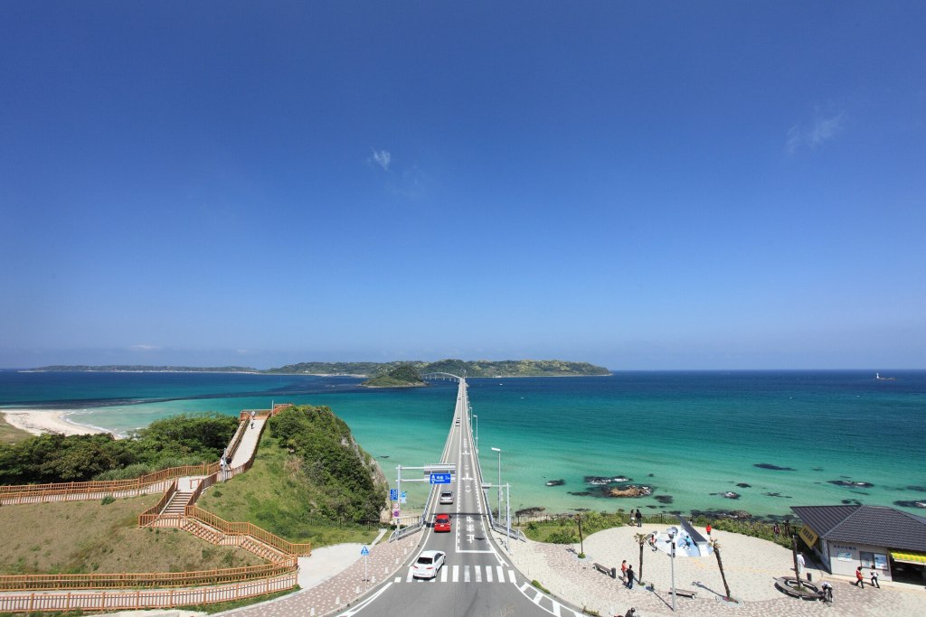
Tsunoshima Bridge is one of those places where the photograph is real. A low white road lifts off the Shimonoseki coast, curves across a shallow strait of the Sea of Japan, and lands on a small island of grazing cattle, granite headlands and a stone lighthouse. The water beneath it shifts from jade to cobalt within a few hundred metres. On a clear morning the bridge appears to float; in winter, when the Japan Sea turns grey and the wind throws spray across the guardrails, it looks like a piece of infrastructure that has survived a negotiation with the weather.
The bridge is the reason most travellers come, but it is not the whole reason to stay. Tsunoshima is a working island of about 600 people, not a theme park. It has a Nara-period paper trail, a Meiji-era lighthouse that still guides ships, a beach of crushed shell, a small museum built around a whale that science did not know existed until 2003, and a north cape where the crowd suddenly disappears. The island is small enough to drive across in ten minutes and rich enough to fill a day.
This guide is written for travellers who want to do more than stop at the viewpoint, take the picture and turn around. It covers the bridge itself, the lighthouse and parks, the beach and museum, the food worth planning around, the bus and driving details, the wind rules that can close the crossing, and the current situation at nearby Motonosumi Shrine. Facts were checked against official Yamaguchi prefecture, Shimonoseki city, lighthouse and operator sources in October 2026. Hours and fees change; reconfirm before you go.
Why Tsunoshima is worth a day, not a photo stop
Tsunoshima sits about 1.5 km off the north-west tip of Yamaguchi Prefecture, in the city of Shimonoseki. It is 3.84 square kilometres of rounded hills, with two capes — Makizaki and Yumesaki — that are said to resemble the horns of a cow. The name is usually explained that way. One local explanation links it to the bend, or kado, where Kitamaebune trading ships turned south into the Inland Sea. Both explanations fit an island that has always been a landmark for people on the water.
The island is part of the Kita-Nagato Kaigan Quasi-National Park, and the scenery changes quickly. The south side, where the bridge lands, is sheltered and green. The west side is exposed granite and lighthouse grass. The north cape is basalt, low scrub and open horizon. Cattle graze near the road in a landscape that has been pasture since the Nara period. You can see all of this in a few hours, but the island rewards a slower loop: one stop for the bridge, one for the lighthouse, one for lunch, one for the beach, one for the cape.
It also makes a practical base for the western Yamaguchi coast. Hagi is about 70 minutes away, Motonosumi Shrine 35–50 minutes, and the Akiyoshidai karst plateau around 75 minutes. If you are driving between Shimonoseki and Hagi, Tsunoshima is not a detour so much as the best possible reason to leave the expressway.
The bridge in numbers
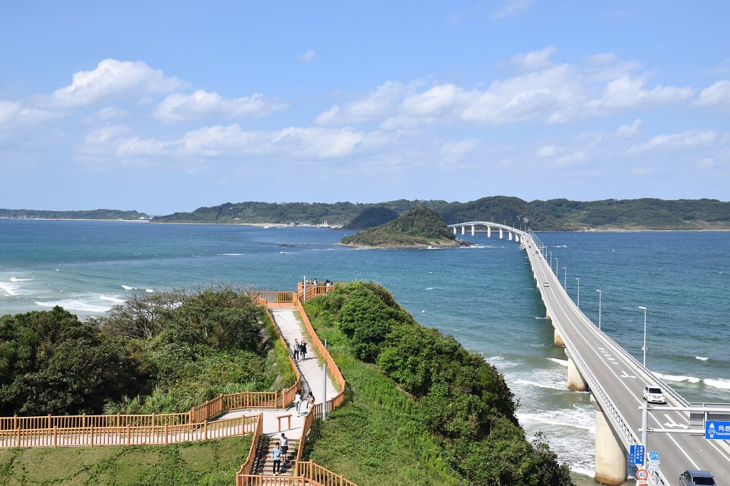
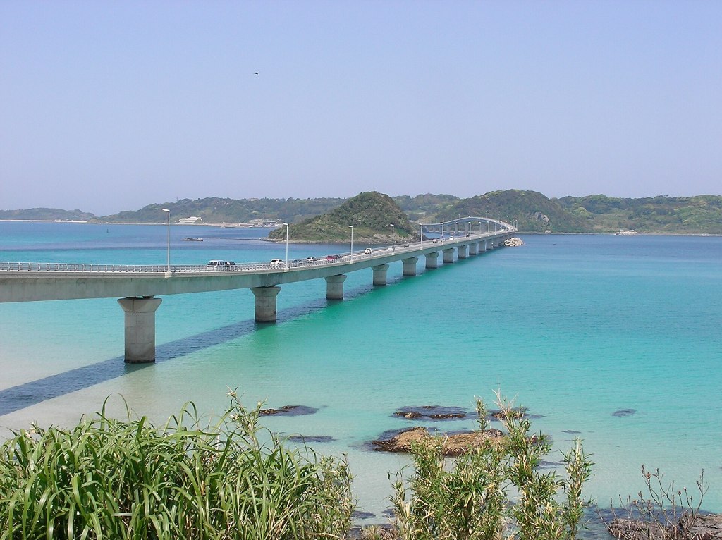
The crossing is officially Tsunoshima Ohashi (角島大橋), on Yamaguchi Prefectural Route 276. It is 1,780 m long, with a carriageway width of 6.5 m — two lanes, with narrow 0.5 m margins — and a navigation clearance of 18 m above the water. It stands on 28 piers, with a maximum span of 102 m. The structure is a composite of continuous prestressed-concrete box girders and a three-span steel-deck box girder over the navigation channel.
Construction began in 1993 and the bridge opened on 3 November 2000. Before that, the island depended on a ferry making about seven round trips a day, and crossings were vulnerable to weather. The bridge ended that isolation. At the time of completion it was the longest free bridge to an inhabited island in Japan; it remains one of the country’s longest toll-free road bridges. Crossing it costs nothing, in either direction.
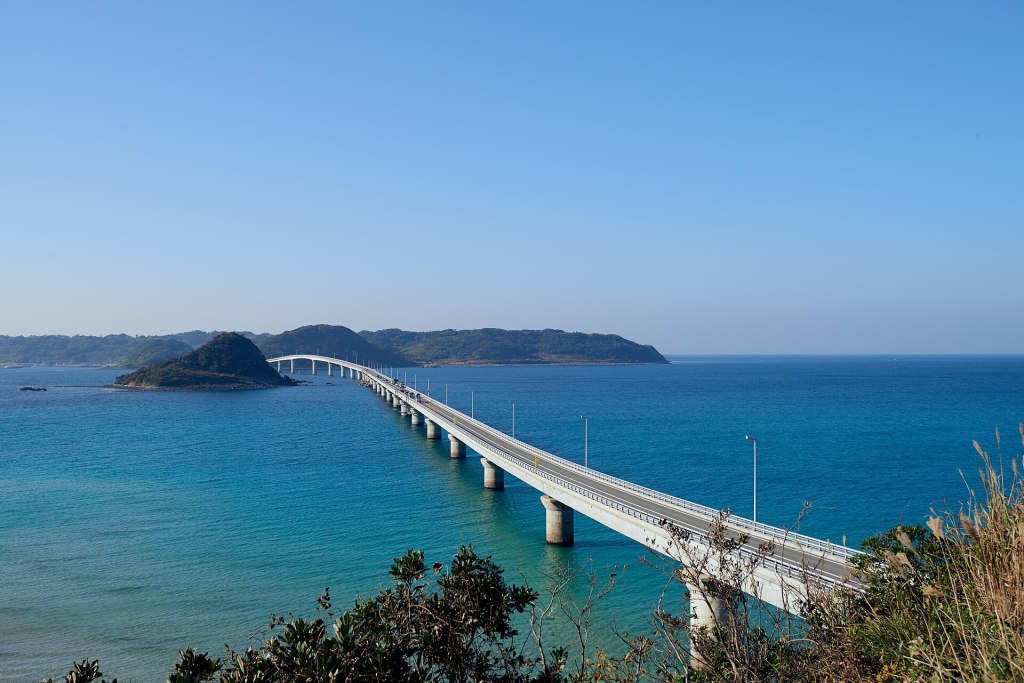
The alignment was designed to sit low in the landscape and to avoid a small islet in the strait, which is why the bridge curves rather than running straight. That curve is also what makes the drive so photogenic: from the mainland side you see the road bend toward the island, and from the island side you see it bend back toward the mainland. The bridge received a design award from the Japan Society of Civil Engineers in 2003, but you do not need to know that to feel how carefully it sits in the water.
Crossing the bridge: viewpoints, light and rules
There are two official places to stop, one at each end. On the mainland side, Amagase Park (海士ヶ瀬公園) has a free car park for about 46 cars, open 24 hours, with toilets, a small shop and a viewpoint. This is the classic postcard angle: the bridge in the foreground, the island behind, and the water changing colour under the span. On the island side, Sezaki Akari Park (瀬崎陽の公園) has about 24 free spaces, a viewpoint and toilets, and looks back toward the mainland. Both are free. Neither has space for large buses.
The light matters. Early morning is usually the calmest and clearest time, before the tour buses and day-trippers arrive. Late afternoon gives a warmer, lower light and a chance of sunset behind the island; the bridge is illuminated from dusk until dawn. Midday in summer is bright and harsh, and the car parks can fill. If you want the empty-road shot, go before 9:00 or after 16:00, and avoid the long weekends.
Do not stop on the bridge itself. There is no lay-by, the lanes are narrow, and the bridge is a working road. The same applies to the approach roads: use the signed car parks, not the verge. If you are cycling, the bridge is exposed and the margins are narrow; the crossing can be closed to bicycles and pedestrians when the ten-minute average wind speed reaches 20 m/s. Walking across is possible in calm weather but is not a comfortable experience, because there is no separate footpath and traffic passes close. The parks give you the view without the risk.
One more rule that surprises visitors: the bridge is not a place for a leisurely roadside picnic. Parking on the approach, setting up a tripod in the lane, or flying a drone over the road can create real problems for local traffic and for other visitors. Use the parks, and follow any on-site signs.
Wind, weather and the road closure to know about
Tsunoshima Bridge has formal wind restrictions. When the ten-minute average wind speed reaches 20 m/s, pedestrians and two-wheeled vehicles — including bicycles — are banned, and cars must proceed slowly. At 30 m/s, the bridge closes to all traffic. This is not a rare formality: the Japan Sea coast gets strong seasonal winds, and typhoons in late summer and autumn can shut the crossing with little warning. Check the forecast and the Yamaguchi road information feed before committing to a day trip, especially if you are on a motorcycle or bicycle.
There is also a roadworks closure that affects access from Shimonoseki in winter 2026–27. National Route 191, the coastal Blue Line, is scheduled to be closed in the Kaneda Ueyama area near Yadama fishing port from 24 November 2026 to 12 March 2027, with a detour in place. The hotel nearest the bridge, Hotel Nishinagato Resort, advises guests to allow extra time and check the detour before travelling. If you are driving from Shimonoseki or coming from the south, confirm the current status; the closure can add a significant loop to what looks like a short coastal drive.
Summer is hot and humid, with the beach at its busiest. Autumn is often the best combination of clear air, comfortable temperatures and good light. Winter is dramatic but exposed: some restaurants shorten their hours, the lighthouse park feels raw, and the sea can be too rough for beach walking. Spring brings daffodils and canola, but also Golden Week traffic. None of these seasons is bad; they are simply different trips.
A short history of Tsunoshima
Tsunoshima appears in some of the oldest records of the Japanese state. A wooden tag excavated from the Nara capital records wakame seaweed from Tsunoshima being sent to the court in 746. The island’s name also appears in the Man’yoshu, the eighth-century poetry anthology, in a verse about the young seaweed in Tsunoshima’s strait. The poem is usually read as a lover’s complaint: the seaweed is wild toward other people but gentle toward the speaker. It is a surprisingly intimate survival for a place now known for a road bridge.
The island’s cattle are not a modern attraction. The Engishiki, a tenth-century compilation of court regulations, lists a state cattle pasture at Tsunoshima. Grazing has continued for centuries, and the animals you see near Makizaki are the latest chapter in that long arrangement. The island’s geography — close enough to the mainland to manage, isolated enough to keep animals separate — made it suitable for a state herd.
In the Edo period, Kitamaebune cargo ships passed offshore on the route between the Inland Sea and the ports of the Japan Sea. Sailors performed a ritual called Tsunoshima mairi, a dance or circuit on the deck, to thank the island and pray for safe passage through the difficult water beyond. The island was a landmark, a hazard and a place of thanks all at once.
The modern era brought the lighthouse in 1876, a military fort in the early twentieth century, and the long decline of the ferry. Tsunoshima became part of Toyohoku Town in 1955 and part of Shimonoseki City in 2005. The bridge arrived in 2000. The population, which was over 1,000 when the bridge was planned, was 602 as of 1 April 2025. That number is the context for everything else: the island is not a resort built for visitors, but a small community adjusting to them.
Tsunoshima Lighthouse: the island’s stone sentinel
The lighthouse stands at the western end of the island, on Yumesaki Cape. It was first lit on 1 March 1876, making it the first large Western-style lighthouse on the Japan Sea coast. It was designed by the British engineer Richard Henry Brunton, the man often called the father of Japanese lighthouses, and built of granite from Tokuyama in what is now Shunan City. The tower is 29.6 m tall, with a focal plane about 45 m above the sea. Its first-order Fresnel lens, designed by Stevenson and made by Barbier in France in 1874, is still in use. The light is 670,000 candela and reaches about 34 km.
In 2020 the lighthouse was designated a National Important Cultural Property, a rare status for a working lighthouse. It is also one of only 16 lighthouses in Japan that the public can climb. The interior is a 105-step spiral staircase of granite, narrow and steep, with a few ladder-like sections. The reward at the top is a 360-degree view: the bridge to the east, the basalt coast to the north, and on a clear day the mainland and the open sea. The staircase is not suitable for anyone who is uncomfortable in tight spaces, and the tower can close in high wind or rough weather.
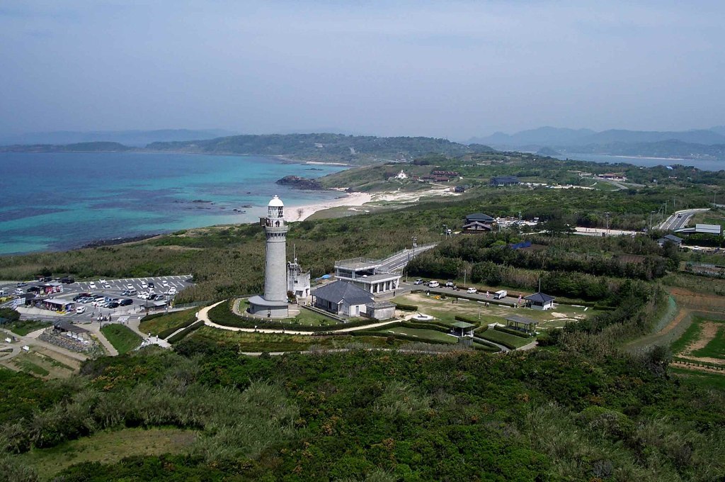
Opening hours are seasonal: 9:00–17:00 from March to September, and 9:00–16:30 from October to February, with last entry 20 minutes before closing. The admission donation is ¥300 for junior high school students and older; elementary school children and people with a disability certificate, plus one companion, are free. The lighthouse is generally open every day, but temporary closures happen. A filming closure is scheduled for the morning of 20 November 2026, from 9:00 to noon. Check the Tokokai lighthouse page or the Yamaguchi tourism listing before making a special trip.
The old keeper’s quarters next to the tower have been restored as a small lighthouse museum. The building is often described as the first brick Western-style building in Yamaguchi Prefecture. The adjacent Tsunoshima Lighthouse Park Observation Gallery is free, open 10:00–16:00, and closed on Thursdays. It is a useful option when the tower itself is closed, and a good place to read about the lighthouse’s construction and the keepers who lived here.
Lighthouse park, flowers and the quiet side of the island
The lighthouse sits inside a park that is free to enter and open at all hours. The Yumesaki Nami Park (夢崎波の公園) next door was laid out in an English-garden style, a nod to Brunton’s origins, with paths, flower beds and benches facing the sea. This is the best place on the island for a slow walk at sunset. The lighthouse is illuminated at night, and the park is a popular spot for photographs of the tower against the last light.
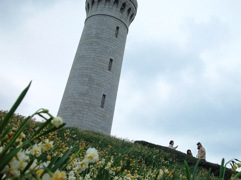
The flowers are seasonal and worth timing. Hamayu (Japanese spider lily, the city flower of Shimonoseki) blooms from mid-July to early August, with white, scented flowers on the slopes above the sea. Daffodils appear from mid-January to mid-February, and the lighthouse with a foreground of narcissus is one of the island’s signature winter images. Daruma-giku, a coastal aster, flowers in October and November and is protected as a designated plant of the quasi-national park. Do not pick any of them. The plants are part of a fragile coastal ecosystem, and the island asks visitors to leave them where they are.
The park has a paid car park (about ¥300 for a standard car, cash, pay on entry) with roughly 32 spaces near the park and a larger 85-space lot on the Yumesaki Nami Park side. Hours are approximately 8:30–17:30 from June to September and 8:30–17:00 from October to May. There is also a small 12-space lot closest to the tower. In peak season these fill early; the free Amagase and Sezaki parks are a fallback, but they are at the bridge, not the lighthouse.
Ohama Beach: white shell sand and a short summer
Tsunoshima Ohama Beach (角島大浜海水浴場) is on the south side of the island, a few minutes from the bridge. The sand is unusually white because it is made largely of fragments of small shells, and the water is clear enough that the gradient from shallow turquoise to deep blue is visible from the car park. The beach faces the strait, so it is sheltered compared with the north coast, but it is still the Sea of Japan.
The official 2026 swimming season runs from 17 July to 31 August, 8:00–18:00. The beach admission or clean-up cooperation fee is ¥1,000 for adults and ¥500 for elementary school children. There are showers (¥200 for two minutes of hot water, ¥100 for cold), changing facilities, toilets and a cooking shelter. Parking is free for about 200 cars. Camping is available in season at the adjacent Ohama campsite, with bungalows and tent sites; the 2026 campsite opens in early July and runs to late August. Barbecues are allowed in the designated area. There is no marine-sports zone, so this is not a jet-ski beach.
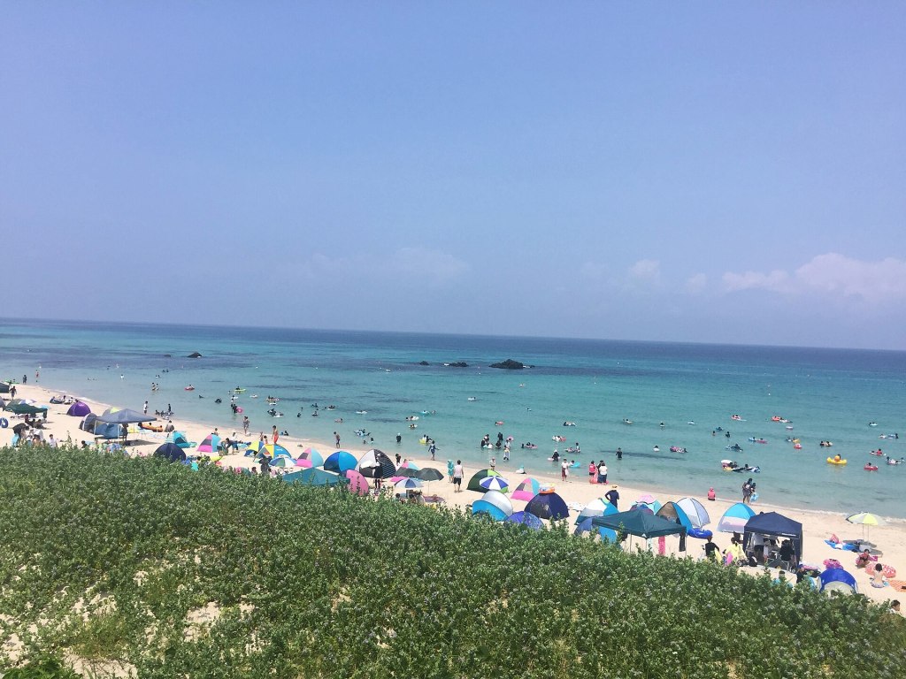
Outside the official season the beach is still open for walking, but there are no lifeguards, no showers and no rental facilities. The water can look inviting in October and still be dangerously cold, and the currents around the strait are not a swimming pool. If you swim outside the season, treat it as a cold-water dip with no support, and do not take children into the water. The beach is also a nesting and feeding area for shore life; take your rubbish home and do not collect shells or plants from the protected areas.
The beach is the best place on the island for a family picnic, but it is not the best place for a quiet sunset. For that, go to the lighthouse side or the north cape. The beach faces the bridge and the mainland, so the sun sets behind the island rather than over the water.
Tsunoshima Nature Museum and the whale that wasn’t supposed to exist
The Tsunoshima Nature Museum (つのしま自然館), also called the Tsunoshima Visitor Center, is a small, well-run museum near Ohama Beach. It explains the island’s geology, plants, birds, insects and marine life, and it is the best rainy-day stop on Tsunoshima. It is also the only place where you can see the skeleton of the animal that made the island famous in marine biology: the Tsunoshima whale.
In September 1998, a whale about 11.5 m long collided with a fishing boat returning to port in the Amagase strait and died. Scientists examined the carcass and found that it belonged to an unknown species of baleen whale. The formal description was published in Nature in 2003, and the animal was named Balaenoptera omurai, or Omura’s whale, after the Japanese cetologist Hideo Omura. It is still rarely seen, and much of its life history remains unknown. The museum displays a detailed replica of the skeleton, including a healed fracture on one rib, and explains how the species was identified.
The museum is open 9:00–16:30, with last entry at 16:00. It is closed on Tuesdays (or the following weekday if Tuesday is a public holiday), and in December and January it is also closed on Thursdays. It closes for the New Year period from 28 December to 4 January. Admission is free, but there is a requested cooperation fee of ¥200; high school students and younger are free. The museum runs nature observation events, usually for ¥200, with insurance and materials included. Allow 30–45 minutes for the exhibits, longer if you have children or an interest in the whale.
The museum is a good place to understand what you are looking at outside. The island’s rocks record volcanic activity, the beaches are a lesson in shell fragmentation, and the strait is a corridor for marine life. It also gives context to the fishing culture that produced the island’s food. If you only have time for one indoor stop, make it this one.
Makizaki Kaze no Park: the island’s quiet edge
Makizaki Kaze no Park (牧崎風の公園) is at the north end of the island, at the tip of Makizaki Cape. It is the least developed and least crowded of the island’s parks, and for many people it is the best. A rough, unpaved loop trail runs around the cape through low grassland, past black basalt outcrops with columnar jointing, and out to an uninterrupted horizon. On a clear day you can see the lighthouse to the west and the mainland coast to the south. In winter, the wind can lift spray into white “wave flowers” over the rocks.
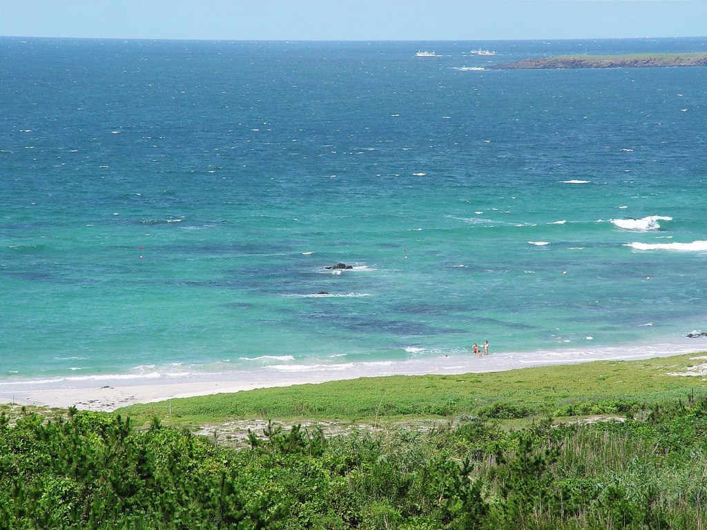
The approach road is narrow, sometimes single-lane, and passes through a working cattle pasture. Cows may be on or near the road. Drive slowly, do not approach the animals, and close any gate you open. The car park is free, with about 30 spaces and a toilet; the toilet has been reported out of service at times, so do not rely on it. The trail is not paved, and the grass can be slippery after rain. Wear shoes with grip and allow 20–30 minutes for the loop.
The cape is also a protected botanical site. Daruma-giku blooms in autumn, and the coastal plant community is designated within the quasi-national park. Do not pick flowers, do not walk off the trail into the nesting areas, and do not fly a drone over the cattle or the cliffs. The park is open all day, but the light is best in the late afternoon, when the sun drops toward the sea and the tour buses have gone.
Food on Tsunoshima: squid, sea urchin and a very early dinner
Tsunoshima is a fishing island, and the food is the second reason to come. The local speciality is Kottoi squid (特牛イカ), named for the Kottoi fishing port on the mainland side. Squid landed there and graded A-rank is marketed as Shimonoseki Kitaura Kottoi squid, prized for sweetness and a tender texture. The island’s restaurants also serve sea urchin, abalone, turban shell, horse mackerel, shirasu, wakame and akamoku, depending on the season and the day’s catch. In winter, the wider Shimonoseki area is fugu country, and many hotels and restaurants serve fugu courses.
The most convenient stop is Shiokaze no Sato Tsunoshima (しおかぜの里 角島), in the centre of the island. The restaurant is open 10:00–15:30, with last orders at 15:00, and the shop is open 9:00–17:00. It is closed on Wednesdays (or the following day when Wednesday is a holiday). The signature dish is a sashimi set using local seafood, and there are rice bowls and grilled items. It is not a secret, and it is not a quiet lunch: the car park holds about 180 cars, and the restaurant is busiest between 12:00 and 13:30. Arrive before noon or after 14:00.
For something more considered, Saizawada (齋座わ田) is a small Japanese restaurant on the island, open 11:00–15:00 with last orders at 14:00, closed on Mondays. It serves seasonal kaiseki and seafood, including a seafood mabushi and a sea-urchin rice bowl. The kaiseki requires a reservation and is limited to a handful of groups per day; the regular lunch is first-come, first-served and the daily special can sell out. It is a cash-and-PayPay kind of place, not a card restaurant. If this is your main meal, call ahead or arrive at opening.
Granvista Tsunoshima (グランビスタ角島) is a restaurant and lodging house near the bridge, with a terrace facing the sunset. It is open 10:00–18:00 (or until sunset, weather permitting), closed on Thursdays except during Golden Week, July and August. The menu runs from Shimonoseki’s kawara soba and seafood bowls to pizza and burgers, and the terrace is pet-friendly. It is the most reliable option for a late lunch or an early dinner on the island, but it is not a late-night restaurant.
For lighter stops, the Yamaguchi tourism association lists Tsunoshima Purin (take-out pudding), Tsunoshima Gelato Popolo (gelato made with Jersey milk and local ingredients), and Shiki no Chaya UTTAU (a renovated old house cafe near the Oshima observatory). Hours change with the season and the day; check their social media before driving out. On the mainland, Doigahama Seafood Restaurant Harumi is about 10 minutes from the bridge and is known for a large seafood bowl. ZERO CAFE on Route 191 is another option for drinks and light food with a sea view.
The practical warning is simple: Tsunoshima eats early. Most restaurants close by late afternoon, and there is no evening restaurant strip. If you are staying on the island, book dinner with your accommodation or plan to eat before 17:00. If you are staying on the mainland, eat at the hotel or drive to Shimonoseki, Nagato or Hagi. Do not assume you can find a table at 19:00 on a quiet Tuesday in November.
How to get to Tsunoshima
By car
The bridge is on Prefectural Route 276, reached from National Route 191. From the Chugoku Expressway, Shimonoseki IC is about 70–80 minutes away, Mine IC about 60–70 minutes, and Otsuki IC about 60 minutes. From JR Shimonoseki Station the drive is about 80 minutes; from Shin-Shimonoseki Station about 70 minutes; from Yamaguchi Ube Airport about 90 minutes. The route is free once you leave the expressway, and the bridge itself has no toll.
Parking is the main constraint. The bridge parks are free but small. The lighthouse parks are paid but larger. Shiokaze no Sato has the biggest lot. In summer and on long weekends, the island’s roads can queue, especially on the bridge approach and around the lighthouse. The official advice is to arrive early or late, and to use the detour via the city road if the bridge exit is congested. Do not park on the shoulder or in a field entrance; the island is a working agricultural landscape.
By train and bus
The nearest stations are JR Takibe and JR Kottoi on the San’in Main Line. From either, the Blue Line bus runs to Tsunoshima. As of the 1 October 2026 timetable, buses leave Takibe at 8:01, 10:40, 11:52, 14:10, 16:21, 17:58 and 18:50, and Kottoi at 6:34, 8:17, 10:50, 12:08, 14:26, 16:37, 18:14 and 19:00. Not every early or late service runs on weekends and holidays; the first Kottoi bus and the last two Takibe buses are marked as weekday-only in the current timetable. The trip takes about 40 minutes from Takibe and 25–30 minutes from Kottoi.
Useful stops are Ohama Beach for the beach and nature museum, Shiokaze no Sato (get off at Gakko-yoko, about one minute on foot), and Todai Koen-mae for the lighthouse, about five minutes on foot. The fare is roughly ¥630 from Takibe and ¥470 from Kottoi to the central island stops. The bus is infrequent, so plan your return before you set out; missing the last bus means a taxi or a long walk. Taxis from Kottoi Station take about 20 minutes and cost around ¥3,000; from Nagato-Furuichi Station, about 20 minutes and a similar fare.
If you are staying at Hotel Nishinagato Resort, the hotel runs a free shuttle from Shin-Shimonoseki Station East Exit, daily, with reservation required at least three days in advance. As of September 2026 the departure time is 13:00. This is a comfortable option if you do not want to drive, but it is for hotel guests and does not replace local transport around the island.
By bicycle
The island is small enough to cycle, and there are rental cycles around Shiokaze no Sato in season. The bridge is exposed, with a narrow margin and a formal wind restriction at 20 m/s. The island’s interior roads are hilly, and the road to Makizaki is narrow. A bicycle is a pleasant way to link the beach and the lighthouse on a calm day, but it is not a good choice in strong wind or rain.
One-day itineraries that actually work
From Shimonoseki or Yamaguchi (full day)
08:00 Leave Shimonoseki. 09:15 Stop at Amagase Park for the classic bridge view and a coffee from the shop. 09:45 Drive across and park at Sezaki Akari Park for the reverse view. 10:15 Lighthouse: climb the tower, visit the museum and walk the park. 11:45 Ohama Beach: a walk on the sand, or a swim in season. 12:45 Lunch at Shiokaze no Sato or Saizawada. 14:00 Tsunoshima Nature Museum. 15:00 Makizaki Kaze no Park for the north coast and the cattle. 16:30 Return across the bridge, or stay for sunset at the lighthouse. 18:00 Back in Shimonoseki for dinner.
This is a full day without rushing. If you are coming from Hagi, reverse the order: lighthouse and beach in the morning, bridge and Amagase in the afternoon, then drive south to Shimonoseki. The light at Amagase is often better in the late afternoon, but the car park can be full; have Sezaki Akari as a backup.
Half-day from Shimonoseki (4–5 hours)
Drive straight to Amagase Park for the view, cross the bridge, spend an hour at the lighthouse, have lunch at Shiokaze no Sato, and stop at Ohama Beach on the way back. Skip the museum and Makizaki if time is short. This is the version for travellers who are passing through on the way to Hagi or Akiyoshidai. It gives you the bridge, the lighthouse and a meal without trying to see everything.
Rainy day
Start at the Tsunoshima Nature Museum, then drive to the lighthouse and climb it if the wind is not too strong. Have a long lunch at Granvista or Shiokaze no Sato. The bridge in rain can be dramatic, but do not stop on it. If the wind is over 20 m/s, the lighthouse may close and the bridge may restrict two-wheelers; check before leaving. A rainy day is a good time to combine the island with the Shimonoseki aquarium or the Hagi museum rather than forcing an outdoor itinerary.
The best time to visit, month by month
January–February: Daffodils around the lighthouse from mid-January to mid-February. Cold, windy and quiet. Some restaurants close or shorten hours. The sea is rough, and the beach is for walking only. This is the best season for photography without crowds, and the worst for swimming.
March–April: Mild and green. Canola may be flowering near Amagase Park in spring. Cherry blossoms are not the island’s main event, but the drive is pleasant. Golden Week at the end of April and the first week of May is one of the busiest periods; book parking and lunch, and arrive early.
May–June: Comfortable temperatures and clear water before the summer crowds. Hamayu begins in July, not May. Rainy season in June can bring grey skies, but the island is quiet and the lighthouse is atmospheric. This is a good time for walkers.
July–August: Beach season (17 July–31 August in 2026), hamayu flowers, and the busiest traffic. The bridge and lighthouse car parks fill by mid-morning. Typhoon season begins, and the bridge can close in strong wind. Book accommodation and dinner in advance. Heat and humidity are significant; carry water and use sun protection.
September–October: Often the best months. The summer crowds thin after mid-September, the light is clear, and the sea is still blue. Daruma-giku begins in October. The 2026 autumn Destination Campaign brought extra events and open-top bus services to the area, which may mean more visitors on certain dates. Check local listings.
November–December: Cool, clear and quiet, with excellent light for the bridge and lighthouse. The Route 191 closure begins on 24 November 2026 and runs to 12 March 2027, so allow extra time from Shimonoseki. Winter fugu season is underway in Shimonoseki. Some island restaurants close earlier or take irregular holidays; call ahead.
Where to stay near Tsunoshima
Hotel Nishinagato Resort is the closest full-service hotel to the bridge, on the mainland side. All rooms face the sea, there is an onsen with an outdoor bath, and the restaurant serves a buffet with local seafood. The hotel completed a renovation in 2026, adding premium rooms with private outdoor baths. It runs a free shuttle from Shin-Shimonoseki Station with advance reservation, and it is the easiest base if you want to see the bridge at sunset and again at breakfast. The winter Route 191 closure affects the approach; ask the hotel for the current detour when you book.
Granvista Tsunoshima is on the island near the bridge, with a restaurant and a small number of rooms. It is the best choice if you want to be on the island for sunrise and sunset without driving back to the mainland. The restaurant closes in the evening, so confirm dinner arrangements when you book. Tsunoshima Ryokan is a traditional small inn in the island’s centre, with Japanese-style rooms and local seafood; it is simple, family-run and often full. There is also a resort pension, Mermaid, near the bridge on the mainland side.
For a wider choice, stay in Shimonoseki (city hotels, fugu restaurants, station access), Nagato Toyoura Onsen (about 40 minutes, with several hot-spring inns), or Hagi (about 70 minutes, with a beautiful castle town and more dining). These bases make sense if you are combining Tsunoshima with Motonosumi, Akiyoshidai or the Hagi sights. Book early for weekends, Golden Week and the summer beach season.
Etiquette and safety on a working island
Tsunoshima is a residential and agricultural island. The lanes between houses are not a maze for visitors, the fields are private, and the cattle are livestock, not a petting zoo. Do not enter fields, do not approach cows or calves, and do not block driveways or fishing access. The island has a small population and a large number of visitors in season; small courtesies matter.
On the road, drive slowly. The island’s main road is narrow in places, the Makizaki road is narrower, and buses, tractors and cyclists share it. Do not stop in the lane for a photograph. Use the car parks and pull-offs. If you are walking, wear shoes with grip for the basalt and the unpaved cape trail, and keep children away from the cliff edge. The lighthouse staircase is steep; anyone with mobility limitations can enjoy the park and the view from the base instead.
On the water, respect the season and the conditions. Swim only during the patrolled season, and never jump from the rocks. Fishing is subject to local rules; night fishing is reported to be prohibited island-wide, and parts of Oyama Port are closed to fishing. Rules can change, so check the signs at the port and ask at the tourist office before unpacking a rod. Do not collect shells, plants or rocks from protected areas, and take all rubbish back to the mainland if the bins are full.
In an emergency, call 110 for police and 119 for fire or ambulance. The nearest hospital is on the mainland, so travel insurance and a charged phone are sensible.
What it costs
Tsunoshima is an affordable day out because the bridge is free. A typical couple travelling by car from Shimonoseki might spend ¥0 on the bridge, ¥0–300 on parking, ¥600 for two lighthouse admissions, ¥1,000–3,000 per person on lunch, and ¥400 for two museum cooperation fees. Fuel and expressway tolls are the largest variable. A beach day in season adds ¥1,000 per adult and ¥500 per child, plus showers. A comfortable day trip without accommodation is often ¥4,000–7,000 per person, excluding transport to the area.
Overnight costs vary widely. A room at the Hotel Nishinagato Resort or a similar resort is typically in the ¥15,000–30,000 range per person with two meals, depending on season and plan. A simple island ryokan or pension can be less. Dinner on the island is early and limited; if you want a late meal, stay on the mainland. The lighthouse and museum are cash-friendly, and some restaurants do not accept cards, so carry some yen.
Motonosumi Shrine and the western Yamaguchi loop
Motonosumi Shrine (元乃隅神社) in Nagato is the most famous side trip from Tsunoshima: 123 red torii tumbling down a cliff toward the sea, about 35–50 minutes by car. It is a spectacular place, and it is also a place with serious access and conservation problems. The road is narrow, the car parks are small, and the shrine has been restoring its torii after storm damage.
As of October 2026, Yamaguchi Prefecture’s official tourism site states that the torii repair work is expected to continue until spring 2027, and that visitors cannot pass through the torii. It also lists worship suspensions on weekends and public holidays from March to November 2026, with some exceptions. Parking is charged by the hour (about ¥300 for a standard car), the shrine is open 7:00–16:30, and there is no practical public transport. The shrine asks visitors to follow the one-way traffic system and not to stop on the narrow approach road.
If you are visiting Tsunoshima in late 2026, do not assume Motonosumi is a simple add-on. Check the official page on the day, go early, and be prepared to see the torii from the allowed viewing area rather than walking through them. If the shrine is closed, the drive along the north coast is still beautiful, and Nagato has other stops: the Kitaura coast, the fish market at Senzaki, and the hot springs at Nagato Toyoura. The combination of Tsunoshima and Motonosumi is excellent when both are open; it is frustrating when one is closed and you have not checked.
Related guides for the rest of the loop
If you are building a western Yamaguchi itinerary, these guides pair naturally with Tsunoshima:
- Shimonoseki travel guide — fugu, the Kanmon Strait, and the city that sits between Honshu and Kyushu.
- Hagi travel guide — the white-walled castle town and the Meiji Restoration sites, about 70 minutes away.
- Akiyoshidai and Akiyoshido guide — the karst plateau and the underground cave, about 75 minutes inland.
- Kintaikyo and Iwakuni guide — the wooden arch bridge and the castle town further east.
- Japan by season — a month-by-month look at weather, crowds and what is worth planning around.
Frequently asked questions
Is Tsunoshima Bridge free?
Yes. The bridge is a prefectural road with no toll. Parking at Amagase and Sezaki Akari parks is free; the lighthouse car parks charge about ¥300.
Can you walk across Tsunoshima Bridge?
There is no separate footpath, only narrow margins beside the traffic lanes. Walking is possible in calm weather but is not recommended, especially with children. The bridge is closed to pedestrians and bicycles when the ten-minute average wind speed reaches 20 m/s. Use the parks for the view.
How long does it take to see Tsunoshima?
Allow 4–6 hours for the bridge, lighthouse, beach, museum and a meal. A quick photo stop takes 30–45 minutes. A full day lets you add Makizaki Cape and a slow lunch.
Do you need a car?
A car is by far the most practical way to visit. The bus runs about seven or eight times a day from Takibe and Kottoi, and some services are weekday-only. If you rely on the bus, plan around the timetable and choose one or two stops rather than trying to circle the island.
What is the best time of day?
Early morning for calm water and empty car parks, or late afternoon for warm light and sunset. Avoid 11:00–14:00 in summer and on long weekends, when the bridge approach and lighthouse car parks are busiest.
Is the beach good for swimming?
Yes, in the official season (17 July–31 August in 2026), when there are lifeguards, showers and facilities. Outside the season there is no patrol, the water is cold, and the currents around the strait can be strong. Do not treat it as a resort beach in November.
Is Tsunoshima suitable for children?
Yes, with supervision. The beach, museum and parks are family-friendly. The lighthouse staircase is steep and narrow, and the north cape has cliffs. Keep children away from the road and the water edge, and bring car seats for the drive.
What should I eat?
Kottoi squid, sea urchin, abalone, sashimi sets, seafood bowls and wakame. Shiokaze no Sato is the easy choice; Saizawada is the more ambitious one; Granvista is the sunset choice. Eat lunch before noon or after 14:00, and do not count on dinner after 17:00.
Is Motonosumi Shrine nearby?
Yes, about 35–50 minutes by car, but check its current repair and worship schedule before you go. In late 2026 the torii are under repair and access is restricted on many weekends and holidays.
What if the bridge is closed?
Do not drive around barriers. Wait for the road to reopen or change your plans. The bridge closes at 30 m/s and restricts pedestrians and two-wheelers at 20 m/s. Winter storms and typhoons can affect it. Check the Yamaguchi road information feed and your car’s wind forecast.
Before you go
- Check the wind. The bridge has formal restrictions at 20 m/s and 30 m/s. If you are on a motorcycle, bicycle or in a high-sided vehicle, this matters.
- Check the Route 191 closure. From 24 November 2026 to 12 March 2027, the coastal road near Kaneda Ueyama is scheduled to close for works. Allow extra time from Shimonoseki.
- Check the lighthouse. Seasonal hours, ¥300 admission, last entry 20 minutes before closing, and occasional temporary closures. The morning of 20 November 2026 is scheduled to be closed for filming.
- Check Motonosumi. Torii repairs are expected to continue until spring 2027, with worship suspensions on many weekends and holidays. Do not assume access.
- Book lunch or arrive early. Island restaurants close in the afternoon. Shiokaze no Sato is closed on Wednesdays; Saizawada is closed on Mondays.
- Carry cash. Parking, the lighthouse and some restaurants are cash-based. Not every till takes cards.
- Bring layers and grip. The coast is windy, the lighthouse stairs are steep, and the Makizaki trail is unpaved.
- Take your rubbish. Bins are limited, and the island is small. Leave the beaches and parks as you found them.
- Respect the residents. Tsunoshima is a working island, not a resort. Do not block driveways, enter fields, or approach cattle.
- Reconfirm before you go. Hours, fees, bus times and closures change. The official links below are the place to start.
Official sources and useful links
- Yamaguchi Prefecture Tourism: Tsunoshima Bridge — bridge length, parking, access, wind closures.
- Yamaguchi Prefecture Tourism: Tsunoshima guide — island overview, lighthouse, beach, food and driving times.
- Yamaguchi Prefecture Tourism: Tsunoshima Lighthouse — hours, fees, access and contact details.
- Tokokai: Tsunoshima Lighthouse — lighthouse history, lens, height and temporary closures.
- Yamaguchi Prefecture: Tsunoshima island profile — area, population, history, cattle and Man’yoshu.
- Yamaguchi Prefecture Tourism: Tsunoshima Ohama Beach — 2026 season, fees, parking and facilities.
- Tsunoshima Nature Museum: visitor information — hours, closures and cooperation fee.
- Shiokaze no Sato Tsunoshima — restaurant and shop hours, closures.
- Granvista Tsunoshima — restaurant hours, menu and access.
- Hotel Nishinagato Resort — accommodation, shuttle and Route 191 closure notice.
- Blue Line Bus: timetable — current Tsunoshima bus times.
- Blue Line Bus: Takibe/Kottoi–Tsunoshima timetable (PDF) — times and fares.
- Yamaguchi Prefecture Tourism: Motonosumi Shrine — current repair and worship information.
- Japan Society of Civil Engineers, Chugoku Branch: Tsunoshima Bridge — bridge structure and construction history.
- Yamaguchi Prefecture: Tsunoshima Bridge technical leaflet (PDF) — span, width and construction details.
- Kujira Town: Tsunoshima whale exhibit — 1998 stranding and 2003 species description.
- We-Love Yamaguchi: Makizaki Kaze no Park — cape trail, cattle and access notes.
- We-Love Yamaguchi: Tsunoshima parking list — car park capacities and facilities.
- Shimonoseki City: Tsunoshima wakame fishing report (PDF) — Nara-period tribute and island fishing history.
- Shimonoseki City: Tsunoshima cattle pasture and Man’yoshu paper (PDF) — Engishiki reference and ancient cattle pasture.
Verified against official and municipal sources in October 2026. Opening hours, fees and access rules can change; confirm with the operator before travelling.


Leave a Reply