Plan a visit to Cape Hedo at the northern tip of Okinawa, with limestone cliffs, the monument and the wild Yanbaru coast.
Operational details such as opening hours, admission fees, and train times can change. Prefer official pages and reconfirm before you travel (sources checked on 03 November 2026).
Why visit
- Cape Hedo is the northernmost point of Okinawa’s main island, and it is where the island stops being a resort and becomes a cliff. The cape is a limestone headland in the Yanbaru national park, and from the tip the East China Sea and the Pacific meet in an unbroken 180-degree horizon, with nothing between you and the edge of the map. It is one of the few places in Okinawa where the sea is the whole view rather than the backdrop to a beach.
- The landscape behind the cape is the other half of the story. The hills are made of limestone more than 200 million years old, pushed up and weathered into a terrain of jagged ridges and sinkholes, and the forest that covers them is the subtropical Yanbaru, now a World Natural Heritage site. It is a forest of giant ferns, of the Yanbaru rail and the Okinawa woodpecker, and of a density of endemic species found nowhere else in Japan.
- The observation deck is the practical reason the cape works as a stop. The Hedo Misaki information centre opened in 2019 at the car park, with a free observation deck on the third floor, a cafe on the second, and a shop and counter on the first, and it is the only place on this coast with a proper view, a toilet and a coffee in one building. The deck looks north over the open sea and south over the limestone mountains, which is the whole geography of the cape in one turn.
- The monument at the tip is not scenery. The stone marking the struggle for the return of Okinawa to Japan was erected in April 1976, four years after the reversion, and its inscription records the history of the movement and the unresolved questions of the bases and of peace. It gives the cape a political weight that the view alone would not, and it is the same coast where the smoke signals were lit.
- The access is the test of whether you want it. The cape is about two hours from Naha by expressway and the Route 58 north, and about three hours on the ordinary roads, and the bus route requires two changes and a village bus with four services a day, two of which must be reserved by phone. That distance keeps the cape quiet in a way that the beaches of the south are not, and it is the reason to come.
- The combination is what makes a day of it. Oishirinzan, the forest of limestone pinnacles, is five minutes away by car, the pine avenue of Sai On is on the road back, and the grave of King Gihon is nearby, so the cape is the end of a loop through the Yanbaru rather than a single stop. With the northern resorts of Okuma and Ada within reach, it is a full day from almost anywhere on the island.
Top places and highlights
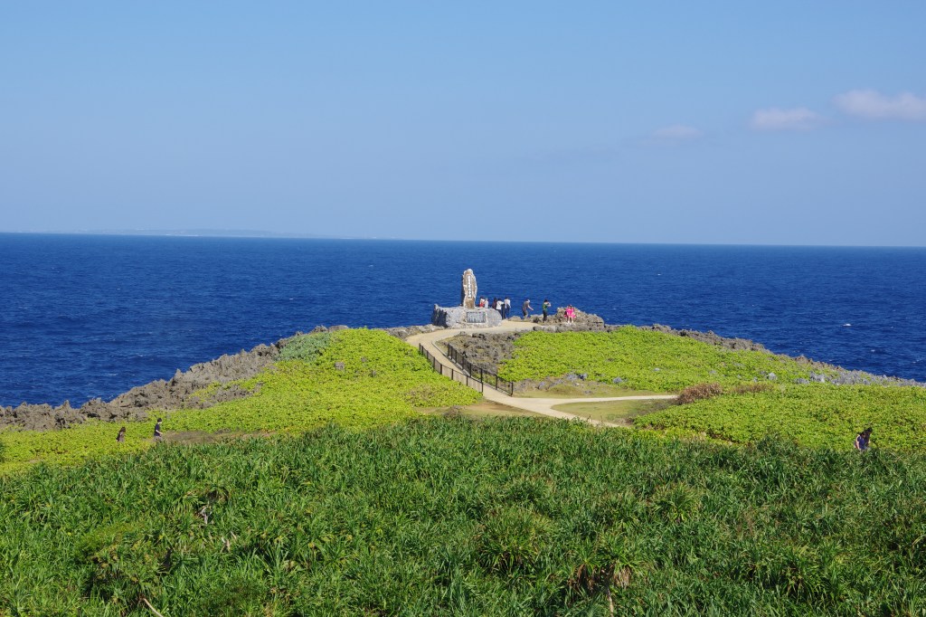
The northernmost tip
The cape is the end of the main island, and the view from the rocks is the East China Sea on one side and the Pacific on the other with no land in between. The water below is deep and clear and the colour changes with the sky, and on a windy day the spray comes up over the platform. There is no fence and no ticket, and the walk down to the point takes a few minutes.
The observation deck
The third-floor deck of the information centre faces north over more than 180 degrees of open water, and to the south it looks at the limestone mountains of the Yanbaru. Entry to the building and the deck is free, the deck is open 10:00 to 16:45, the cafe 10:00 to 17:00 with last order at 16:30, and the information counter 10:00 to 17:00, every day of the year.
The limestone mountains
The hills behind the cape are a raised limestone plateau, more than 200 million years old, weathered into ridges and hollows and covered in subtropical forest. It is the same rock that makes Oishirinzan, and the forest on it is the Yanbaru World Natural Heritage site. The road south from the cape runs through it, and the mountains are the reason the drive is worth more than the destination.
The reversion monument
The stone at the tip was erected in April 1976 and records the movement for the return of Okinawa to Japan, which was achieved on 15 May 1972, and the questions of the bases and of peace that remained after it. It is a serious monument in a beautiful place, and it is the reason the cape is more than a viewpoint. The smoke signals of the movement were lit on this coast.
The Yanbaru forest
The forest around the cape is the habitat of the Yanbaru rail, discovered in 1981, and of the Okinawa woodpecker, both of which are found only here, along with a long list of endemic insects, snails and plants. The birds are hard to see without a guide and a very early start, but the forest itself is on both sides of the road, and the roadside signs explain what is in it.
The cafe above the sea
The Fushikubu cafe on the second floor of the information centre has a terrace facing the water, and it is the only place to sit with a coffee at the top of the island. It serves light meals and drinks with a view over the East China Sea, and it closes at 17:00 with last order at 16:30, which is worth knowing before the drive back.
Oishirinzan
Five minutes by car from the cape, Oishirinzan is a forest of limestone pinnacles and boulders with walking paths through it, and it is the same rock as the hills behind the cape, seen from inside. It is a paid site with its own opening hours, and it is the natural pair with the cape for a half day in the far north.
Food and drink
- The food of the far north is simple and local: Okinawa soba, the pork and the bitter melon, and the seafood landed at the small ports. The restaurants around the cape are few and the best of them are the local canteens rather than destination dining.
- The Hedo Misaki Koyo Parlour near the car park serves shaved ice with local fruit, soft cream, soki soba and taco rice, and it is the practical stop for a hot day. The Fushikubu cafe in the information centre has the view and the coffee.
- The Kunigami port canteen near the Okuma beach serves tempura and seafood bowls from the local catch, and the Himawari canteen is a long-established local place known for its soki soba. Both are a drive from the cape rather than at it.
- The pineapple and the tropical fruit of the north are sold at the roadside stands, and the juice and the fruit are the best value. The local craft beer and the Yanbaru produce appear in the shops of the information centre, which is a good place to buy them.
Getting there and around
- By car from Naha, take the Okinawa Expressway to the Kyoda interchange, about 55 minutes, then Route 58 north for about an hour to the cape. From the airport on the ordinary roads it is about three hours, and from the Kyoda interchange about an hour and 20 minutes.
- By bus, take the express bus 111 or 117 from Naha to the Nago bus terminal, about an hour and 40 minutes for 2,520 yen, then the number 67 Okinawa bus to the Hentona terminal, about an hour for 1,070 yen, then the Kunigami village bus for the cape, about 34 minutes for 500 yen.
- The village bus runs four times a day, and the two morning services at 10:00 and 11:00 are reservation services that pick up and drop off where you ask, booked by phone with the Kunigami village office on 0980-41-2101. Missing one means a long wait or a taxi.
- The car park at the cape is free and holds 70 vehicles, with space for large buses, and there is a wheelchair-accessible lift and wheelchairs available at the information centre. The building and the deck are free to enter.
- The cape is a stop on the Yanbaru loop: Oishirinzan is five minutes away, the Sai On pine avenue and the tomb of King Gihon are on the road back, and the resorts of Okuma and Ada are within half an hour. A car is the practical way to see any of it.
Where to stay
- The far north has few hotels, and the ones that exist are the Okuma private beach resort, the small lodges and minshuku of Kunigami village, and the guesthouses around Hentona. They are quiet and close to the forest rather than to a town.
- Nago, about an hour south, is the main base for the north, with hotels of every kind, restaurants and the bus terminal. From Nago the cape is a day trip, and the drive up the coast is part of the reason.
- The resorts of Onna and the west coast are two hours away and are a different Okinawa, with the beaches and the diving. Staying in the north instead gives the forest and the empty roads, and the cape at sunrise without a two-hour drive.
Best time to visit
- The best months are from October to April, when the air is dry, the sea is clear and the heat is manageable, and the walk to the tip is comfortable. The winter wind is strong on the cape and the spray is part of the experience.
- Summer is hot and humid, and the cape is exposed with little shade, so the early morning and the late afternoon are the only sensible hours. The sea is at its most blue and the swimming is at the beaches rather than the rocks.
- The rainy season in May and June brings cloud and short heavy showers, and the views from the deck come and go with the weather. The forest is at its greenest and the waterfalls and streams are full.
- Typhoon season from August to September can close the roads and the cape, and the wind at the tip is dangerous in a storm. Winter also brings the strongest swells, and the rocks at the point should not be approached in high seas.
Practical tips
- Fill the tank before the last stretch. The petrol stations thin out north of Nago, and the road to the cape has no services for the final hour. The same applies to cash, since the village shops and the small restaurants may not take cards.
- Go early or go for the late afternoon. The cape is a two-hour drive from Naha and the day trippers arrive in the middle of it, and the light on the water is best before 10:00 and after 15:00. The deck closes at 16:45, so the sunset is seen from the rocks rather than the platform.
- Reserve the village bus if you are going by public transport. Only the 10:00 and 11:00 services are bookable and the rest are infrequent, and the phone number is the village office’s, on 0980-41-2101. The bus is not a hop-on service.
- Do not walk out onto the wet rocks at the tip. The point is exposed and the swell comes up without warning, and there are no railings or lifeguards. The view from the platform and the path is the safe one.
- Bring a layer even in summer. The cape is windy and the deck is exposed, and the temperature at the northern tip is lower than in Naha by several degrees. The wind is the thing people underestimate.
- Combine the cape with Oishirinzan and the pine avenue. The three are within minutes of each other and make a proper half day in the Yanbaru, and Oishirinzan has its own opening hours and admission, so check them before setting out.
- Try the cafe for the view rather than the meal. The Fushikubu cafe on the second floor is the only place to sit above the sea at the top of the island, and its last order is at 16:30. The parlour by the car park is better for a quick cold drink.
Suggested day-trip outline
- Leave Naha early and take the expressway to Kyoda, then Route 58 north through Nago and along the coast. Stop at the roadside stands for fruit and at the viewpoints on the way, and reach the cape before the middle of the day.
- Walk down to the tip and the reversion monument, then go up to the third-floor deck of the information centre for the 180-degree view north and the limestone mountains south. Have a coffee on the second-floor terrace before the last order at 16:30.
- Drive five minutes to Oishirinzan and walk the paths through the limestone pinnacles and the subtropical forest, then take the road back past the Sai On pine avenue and the tomb of King Gihon. The forest is the other half of the Yanbaru and it is best seen on foot.
- Eat at one of the local canteens on the way south, and if the season is right, stop at a beach on the west coast for the sunset. The drive back to Nago takes about an hour in the dark and the road is unlit in places.
- Stay in the north for a second day if you want the forest properly: the Yanbaru guided walks and the early morning birding need a start before dawn, and the cape is the natural end of that day rather than its beginning.
Before you go
Timetables, fares, admission fees, and seasonal access rules can change. Check the official tourism and transport sites linked below for the latest information before you travel.
Explore More of Japan
Published guides that pair with this one:
- Cape Manzamo Travel Guide: Elephant Rock, Sunset and the Onna Coast
- Kouri Island Travel Guide: The Heart Rock and a Bridge over Emerald Water
- Cape Zanpa Travel Guide: Yomitan’s Cliffs and Lighthouse
- Shikinaen Garden Travel Guide: Naha’s Ryukyu Royal Garden
- Okinawa Prefectural Museum and Art Museum Travel Guide: Highlights, Access, and Planning
- Okinawa Peace Memorial Park Guide: Mabuni and the Battle Sites
- Tokashiki Island Guide: A Kerama Day Trip from Naha
Browse every Okinawa guide on this site for the rest of the region.
Sources
- hedomisaki-okinawa.com (checked 2026-11-03)
- hedomisaki-okinawa.com — Access (checked 2026-11-03)
- kunigami-kanko.com (checked 2026-11-03)
- cape-hedo-platform.org (checked 2026-11-03)
- yambaru-tour.net (checked 2026-11-03)


Leave a Reply