Plan a trip across the Shikoku Karst highland, with the ridge road, the lodging and camping bases, access routes, and the winter closure.
Operational details such as opening hours, admission fees, and train times can change. Prefer official pages and reconfirm before you travel (sources checked on 03 November 2026).
Why visit
- The Shikoku Karst is a highland ridge on the border of Ehime and Kochi, around 1,400 metres above sea level, where the limestone has produced open grassland rather than the forest that covers most of Shikoku. The result is a road along the top of a mountain with grass on both sides and almost nothing vertical in the view, which is rare in Japan and unlike anything else on the island. It is a landscape rather than a sight, and the thing to do is drive it, stop often, and walk out onto the grass.
- The name is a geological description rather than a marketing term. Karst is limestone country, and the plateau here is a prefectural natural park with the bare, rolling topography that comes with it: no tall trees, thin soil, and drainage that disappears underground. Because the ridge is high and open, the weather sits on it directly, which is why the area is known for cloud seas, fog and sudden changes rather than for a stable view.
- The two centres are Mezurudaira on the Ehime side and Tengu Highland on the Kochi side, and they are different in character. Mezurudaira is the base with the lodging, cottages and a campsite at about 1,400 metres, and Tengu Highland is higher still at 1,485 metres with its own hotel, planetarium and restaurant. Both are places to sleep on the ridge rather than day-trip facilities, and staying at either is how you see the sunset and the stars that the area is actually famous for.
- The stars are the other reason people come, and the area does not oversell them. The official advice is blunt: on a clear night without a large moon you can see the Milky Way with the naked eye, but there are about as many nights when you cannot see it as nights when you can, and the weather is worse than the forecast for the towns below. That honesty is useful. It also means that a clear night here is worth rearranging a trip for, and a cloudy one is normal.
- The access is the part that decides whether you go. There is no public transport at all: the town bus to Tengu Highland was abolished in 2017, and the operators say so plainly. Only the main forest road, the Totsuno-Jogawa line, is two lanes, and every other approach is narrow enough that passing another car is difficult. This is a drive-in destination, and the drive is part of the experience rather than a cost to be minimised.
Top places and highlights
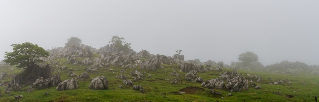
The ridge road itself
The Shikoku Karst traverse road runs along the top of the ridge between the Ehime and Kochi sides, and it is the main attraction: grass to the horizon, limestone outcrops, and a road that follows the crest rather than cutting through it. The official guidance notes that only the Totsuno-Jogawa forest road is two lanes, and that all the other approaches are narrow with difficult passing places. Take the wide road in and enjoy the ridge without worrying about the car.
Mezurudaira and its view
Mezurudaira is the plateau at about 1,400 metres on the Ehime side, with the Mezuru-so lodge, cottages and a campsite, and it is the most convenient base on the ridge. The view from the top takes in the Shikoku mountains, including Mount Ishizuchi, the highest peak in western Japan, and on a clear day the Pacific is visible in the distance. The live camera at Mezurudaira is the practical way to check whether the ridge is clear or buried in fog before you drive up.
Tengu Highland and the stars
Tengu Highland, on the Kochi side, sits at 1,485 metres and holds the Shin-Furu Village Tengu hotel, with a planetarium for the nights when the sky does not cooperate and glass-roofed rooms for the nights when it does. The restaurant serves lunch from 11:00 to 14:30 with last orders at 14:00, and outside those hours it is for guests only. This is the higher and more comfortable of the two bases, and the one to choose if the night sky is the point of the trip.
The campsite at Mezurudaira
The Mezurudaira campsite is a free site on grass at 1,400 metres, with a 2026 rate of 1,500 yen for a weekday or Sunday night and 2,500 yen on Saturdays, holiday eves and peak periods, covering one tent, one tarp, one car and up to six people, plus 500 yen per person as an environment fee. Check-in is 13:00 to 19:00 at the lodge and check-out is 10:00, and camping outside the site is not allowed. It is the cheapest way to be on the ridge at sunset and sunrise.
The sea of clouds
The area is known for cloud seas, which form most often after rain when the humidity is high, and at dawn or around sunset. The official advice is that the ridge is about five degrees colder than the Kumakogen forecast and that fog can leave you with a completely white view, so the cloud sea is a matter of luck and timing rather than a scheduled event. Staying overnight roughly doubles your chances, because it gives you both the evening and the morning.
The autumn grass
The plateau turns to silver grass in autumn, and the official guidance puts October to early November as the clearest period of the year, with good star visibility on three or four nights a week and cloud seas more likely in the morning. The trade is that it gets cold quickly and the facilities begin closing in November, so late October is the narrow window where the weather, the colour and the opening dates all line up.
Food and drink
- Mezuru-so on the Ehime side has a restaurant, a shop and a soft-serve counter, and it is the only reliable place to eat on that part of the ridge. In 2026 the restaurant was scheduled to close on 8 November, with a day off on 6 November, while the shop and the coffee stand were to continue until 16 November, so the eating options disappear before the accommodation does.
- Tengu Highland’s restaurant serves lunch from 11:00 to 14:30 with last orders at 14:00, and outside that window it is for hotel guests only. Anyone arriving in the late afternoon expecting a meal should not count on it, and the same applies to the Kochi side out of season.
- There are no shops, convenience stores or petrol stations on the ridge, and the practical supply points are Kumakogen on the Ehime side and Tsuno on the Kochi side. The official guidance notes that most petrol stations in Kumakogen are closed on Sundays, which is a specific warning worth taking seriously on a mountain with no services.
- The local advice is to arrive with food and cold-weather gear rather than to expect to buy either, and the campsite page says the same thing directly: secure your equipment, your cold-weather clothing and your food before you come up. The nearest supermarket is about an hour away in Kumakogen or about 40 minutes in Tsuno.
Getting there and around
- By car from Ehime and Matsuyama, the shortest route is Route 33 to Route 440 to Prefectural Route 383 over the Jiyoshi Pass, which is the route a navigation system will choose if you set Mezuru-so as the destination. The last nine kilometres are narrow, and the operators themselves recommend a different road for anyone who dislikes narrow lanes or reversing.
- From Kochi city, the recommended route is the Kochi Expressway to Susaki Higashi interchange, then Prefectural Route 315, then Route 197, then the main forest road, the Totsuno-Jogawa line. That road is the only two-lane approach to the ridge and the one to use if you are at all uncertain, even though it is about 40 kilometres longer than the direct route.
- From Kagawa, Tokushima and the Seto Ohashi area, the guidance is that coming via the Kochi Expressway and Susaki is faster than going through Matsuyama, which is counter-intuitive and worth planning around. From the Shimanto coast and Ashizuri, the route is the expressway to Susaki Nishi, then Route 197, then the forest road.
- There is no public transport. The town bus to Tengu Highland was discontinued in 2017 and the operators state plainly that the karst cannot be reached by public transport, which makes this one of the few major scenic areas in Shikoku that absolutely requires a vehicle. Taxis are possible but the fares from the nearest towns are substantial.
- The winter closure is the single most important date to check. The traverse road closes for the season when snow makes it unsafe, and the dates vary widely: 5 December in 2025, 2 December in 2024, 24 November in 2023, 6 December in 2022 and 29 November in 2021. The closure is announced rather than fixed, so anyone travelling in late November or December should confirm the status before setting out.
Where to stay
- Mezuru-so at Mezurudaira is the classic base, a simple lodge at about 1,400 metres with rooms, cottages and a campsite, and it is the place to stay for the ridge itself. The 2026 season ran its lodging to 15 November, with the cottages closing earlier than the rooms, and the whole site then closes for the winter.
- The Mezurudaira campsite is the budget option and arguably the better one for the purpose, since it puts you on the grass for the sunset and the stars. Rates are 1,500 yen on weekdays and Sundays and 2,500 yen on Saturdays and peak nights, plus 500 yen per person, and the season in 2026 was scheduled to end with the night of 22 November.
- Shin-Furu Village Tengu at 1,485 metres on the Kochi side is the comfortable option, with a planetarium, glass-roofed star rooms and a restaurant, and it stays open in winter with a free shuttle for guests during the season. It is the choice for anyone whose priority is the night sky and a warm room rather than a tent.
- Below the ridge, Kumakogen on the Ehime side and Tsuno on the Kochi side have ordinary town accommodation and are the fallback when the plateau is closed or full. They are about an hour and forty minutes respectively from the ridge by road, which is a long way to come for a sunset.
Best time to visit
- October to early November is the strongest window: the official guidance puts the clear-sky rate at its highest, with good star visibility on three or four nights a week, silver grass on the plateau, and cloud seas more likely in the morning. It is also when the facilities begin closing, so the last week of October is the point where everything is still open and the weather is still good.
- Summer is cool and green, and the ridge is at its most comfortable when the towns below are hot, with the Milky Way visible for most of the night on a clear evening. The trade is typhoon season, when even a distant typhoon off Kochi destabilises the weather and brings fog and wind, and the operators advise cancelling a stay rather than riding one out.
- The rainy season in June and early July is the quietest and least reliable period, with fog on more than half the days and a real chance of seeing nothing at all. The compensation is that a clear day in the rainy season is exceptionally clear, and the plateau is empty.
- Winter closes the traverse road and most of the facilities, and the ridge becomes a serious mountain rather than a drive. The Kochi side stays open at Tengu Highland with a winter shuttle, so a winter visit is possible but is a different trip: fewer roads, more snow, and no casual drive along the crest.
Practical tips
- Check the live camera before you drive up. Both the Mezurudaira operators and the Tengu Highland hotel warn that fog can leave the ridge completely white with no view at all, and the camera at Mezurudaira updates every ten minutes. It is the difference between a wasted two-hour drive and a good one, and the weather forecast for the towns below does not tell you what the ridge is doing.
- Take the wide road in. Only the Totsuno-Jogawa forest road is two lanes, and the shorter approaches over the Jiyoshi Pass and other routes are narrow with difficult passing. The longer route is about 40 kilometres further and worth it for anyone not confident on mountain single-track.
- Fill the tank before you climb. There are no petrol stations on the ridge, and most stations in Kumakogen are closed on Sundays. The same applies to food: there are no shops, and the nearest supermarket is 40 minutes to an hour away, so arrive stocked.
- Book the season’s end carefully. In 2026 the restaurant at Mezurudaira was due to close on 8 November, the shop and coffee stand on 16 November, the lodging on 15 November and the campsite with the night of 22 November, and the cottages had already closed for the year. The dates move each season, so check the operators’ notice rather than assuming last year’s calendar.
- Expect it to be about five degrees colder than the forecast for Kumakogen, and pack accordingly even in summer. The operators say this explicitly, and the ridge is exposed with no shelter between the two bases. A clear night that is perfect for stars is also a cold night.
- Confirm the winter road closure if you are travelling from late November. The traverse road has closed on dates ranging from 24 November to 6 December in recent years, and the closure is announced when the snow arrives rather than fixed in advance. A trip planned around driving the crest in December is a gamble.
- Pay attention to the check-in window at the campsite. Check-in at Mezurudaira is 13:00 to 19:00 at the lodge, and pitching a tent before checking in is prohibited. If you arrive after 19:00 you pay the next morning, and if you leave before 8:00 you put the fee in the box by the front entrance.
Suggested day-trip outline
- Drive up in the morning via the Totsuno-Jogawa forest road from the Kochi side, or via Route 33, 440 and 383 from Matsuyama if you are coming from Ehime, and stop at Mezurudaira first to check the conditions and the live camera. The drive itself is the scenery, so do not rush the last hour.
- Walk out onto the grassland at Mezurudaira for the view towards Mount Ishizuchi and, on a clear day, the Pacific. There are walking trails across the plateau, and an hour on foot gives you the ridge properly rather than through a windscreen.
- Drive the crest to Tengu Highland for lunch at the hotel restaurant, which serves from 11:00 to 14:30 with last orders at 14:00, and take in the higher viewpoint at 1,485 metres. If you are staying overnight, this is the point to decide whether to sleep on the Ehime or the Kochi side.
- Stay for sunset and the stars, which is the reason to be here rather than passing through. The plateau is about five degrees colder than the towns below, so have warm clothing ready, and give your eyes ten minutes to adjust before deciding the sky is disappointing.
- Leave after sunrise if you stayed, when the cloud sea is most likely after a humid night, and drive down the wide forest road rather than the narrow pass. Fill the tank and eat in Kumakogen or Tsuno, because there is nothing on the ridge and the next services are an hour away.
Before you go
Timetables, fares, admission fees, and seasonal access rules can change. Check the official tourism and transport sites linked below for the latest information before you travel.
Explore More of Japan
Published guides that pair with this one:
- Matsuyama Castle Travel Guide: The 1854 Keep above the City
- Iya Valley Travel Guide: Vine Bridges and Mountain Villages
- Oboke Gorge Travel Guide: The Yoshino River between the Cliffs
- Shimanto River Travel Guide: Japan’s Last Clear Stream and the Boats That Drift It
- Mount Ishizuchi Guide: Shikoku’s Highest Peak
- The Museum of Art, Ehime Travel Guide: Highlights, Access, and Planning
- Cape Ashizuri Guide: Kochi’s Southern Tip
- Kochi and Katsurahama Guide: The Pacific Coast and Ryoma
- Cape Muroto Travel Guide: Where the Pacific Meets the Geopark
- Dogo Onsen Travel Guide: Historic Hot Springs in Matsuyama
Browse every Shikoku guide on this site for the rest of the region.
Sources
- karst.co.jp (checked 2026-11-03)
- karst.co.jp — Access (checked 2026-11-03)
- karst.co.jp (checked 2026-11-03)
- karst.co.jp (checked 2026-11-03)
- village-tengu.com (checked 2026-11-03)


Leave a Reply