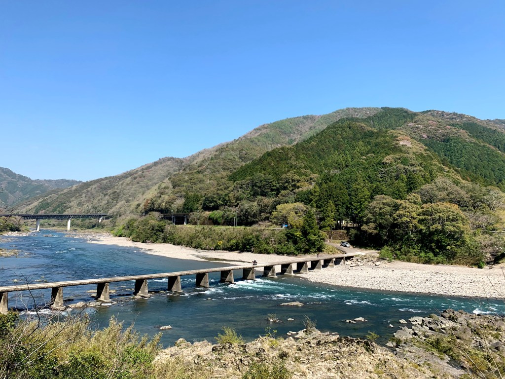
The Shimanto is the river Japanese people mean when they say clear. It runs 196 km across western Shikoku, from a spring on Mount Irazu to the Pacific at Shimanto city, and for most of that distance it looks the way rivers looked before concrete: broad gravel banks, green water, bamboo and cedar on both sides, and low bridges without railings that disappear under the surface when the river rises.
It is not a resort. There is no strip of hotels, no gondola, no light show. What there is: a handful of small towns, boats poled by fishermen, rental bicycles, eel restaurants, and water so clear you can count the stones. This guide covers how to get there, what to do on and beside the river, the 2026 boat operators, the best season for each kind of trip, and the practical details that decide whether a visit feels relaxed or rushed.
Why the Shimanto
Because it is a working river that stayed alive. The main stem has no large dam, which is rare in Japan, and the 47 chinkabashi, the sunken bridges, are still used by local people every day rather than preserved as exhibits. The river supports ayu sweetfish, eel, river shrimp and nori, and the towns along it are small enough that a visitor is a guest rather than a customer.
It is also an easy dose of countryside. Kochi city and Matsuyama are both reachable by train, and the limited express from Kochi runs along the river for the last part of the journey. You can leave the city after breakfast and be on a boat under a chinkabashi by lunch.
The river in numbers
The Shimanto rises on Mount Irazu, 1,336 metres up in Tsuno town, gathers 319 tributaries, and empties into Tosa Bay at Shimanto city. It is 196 km long, the longest river in Shikoku and the eleventh longest in Japan, and drains a basin of about 2,200 square kilometres.
Its reputation comes from the absence of major dams on the main river and from the quality of the water, which stays clear even after rain because much of the basin is forest. The river is also the reason the surrounding towns exist: fishing, farming and timber all depended on it, and the bridges were built to keep those communities connected.
A short history
The chinkabashi were built mainly between the 1930s and the 1950s, by local communities rather than by large contractors. With no railings and low piers, they were cheap to build and safe in floods: when the river rises, the water simply flows over the deck, and the bridge survives. That design is why they are still standing, and why they are still repaired rather than replaced.
The river escaped the dam-building of the post-war decades, and the nickname “Japan’s last clear stream” took hold in the 1970s, when other rivers were being engineered for power and flood control. That reputation brought tourism, and the towns have kept the balance mostly on the side of the river: small boats, small hotels, and rules about where you can swim and fish.
The shape of the river
The upper river, around Ekawasaki and Kubokawa, is narrow and fast, with rafting and canoeing operators, a road station, and the Yodo Line railway running beside it. This is the mountain end, and the water is cold even in summer.
The middle reaches are the quiet part, with farmland, small villages and long gravel banks. The lower river around Nakamura and Sada is the classic image: wide, slow, with the longest chinkabashi and the boat piers. Most first-time visitors base themselves in Shimanto city and see the river from Sada downstream.
Getting there
From Kochi, the JR limited express Nanpu runs to Nakamura in just over two hours, following the river for the last stretch. From Matsuyama or Uwajima, take the JR Yodo Line to Kubokawa and change to the Tosa Kuroshio Railway for Nakamura; the Yodo Line itself is one of Japan’s prettiest rural railways.
By car, the expressway ends around Shimanto-chuo Interchange, and the last hour is on ordinary roads. A car is the most practical way to reach the bridges and the boat piers, but the train plus a rental bicycle works well for a short visit focused on Sada.
Nakamura Station is the transport hub for the lower river. It has a tourist information desk, rental bicycles, and buses to the coast at Ashizuri, though the bus timetables are thin.
Getting around
Rental bicycles from Nakamura Station are the best low-cost option: Sada chinkabashi is about 6 km away, a 40-minute ride on flat roads, and the ride itself is part of the experience. Electric-assist bicycles make the return easy in summer.
For the upper river and the more remote bridges, you need a car. Local buses connect the towns but not the riverbanks, and taxis are few. If you are relying on public transport, choose one base and one stretch of river rather than trying to see the whole 196 km.
The chinkabashi
A chinkabashi is a bridge designed to sink. There are no railings, the piers are low, and in a flood the river runs over the top. They are one lane wide, used by locals in kei cars and by cyclists, and they are not a playground: people have been swept off them.
Sada chinkabashi, officially Imanari Bridge, is the longest at 291.6 metres, 4.2 metres wide, and was completed in 1972. It is the closest to Nakamura and the most photographed, especially at sunset when the low light catches the water. The view from the middle, with the river on both sides and no railing in front of you, is the image most people come for.
Other bridges worth seeking out are quieter and often empty. Drive or cycle slowly, give way at the ends, do not stop in the middle for photographs when a local car is waiting, and never walk on the deck during high water.
On the water
Two established operators run covered boats near Sada. Yakata-bune Sakoya leaves from beside Sada chinkabashi, runs about 50 minutes to Sanri chinkabashi and back, charges 2,000 yen for adults and 1,000 yen for primary school children, and prefers bookings; its firefly boat runs for about two hours on spring evenings. Shimanto no Ao leaves from the Sanri pier, runs hourly from 9:00 to 16:00, takes about an hour, and charges the same fares.
Both boats pass under the bridges, which is the point: from the water you see the structure, the gravel banks and the forest in a way the road never shows. Boats can be cancelled after heavy rain or when the river is high, so call ahead in the rainy season.
Travellers driving to the Sada pier should note that the tunnel on the approach was closed on weekdays from 19 October to 19 November 2026, with a detour in place. Check the operator’s site before setting out if you are visiting in that window.
Canoeing and kayaking are the other way onto the water. Operators around Kubokawa and Ekawasaki run half-day and full-day trips, including family routes on calm sections. Swimming is possible at the designated spots near the bridges in summer, but the current is stronger than it looks, and there are no lifeguards.
Fishing and river food
The Shimanto is a fishing river, and fishing is regulated. Ayu sweetfish are caught with rod and reel and with the traditional cormorant-style method in some seasons, and the river also produces eel, river shrimp and small goby. If you want to fish, join a guided experience or buy the correct permit; do not borrow a rod and assume it is fine.
In winter the river yields ao-nori, a green laver harvested from the shallows and used in soups and rice dishes. It is a small industry with a short season, and the restaurants that serve it are proud of it.
Towns and stops
Nakamura, in Shimanto city, is the base: station, shops, eel restaurants, and the river ten minutes away. Iwamoto-ji, the 36th temple on the Shikoku pilgrimage, is in the hills above town and makes a quiet half-day.
Sada has the bridge, the boat piers and a few cafes. Sanri has the second pier and a riverside park. Ekawasaki has a road station, the Yodo Line station, and access to the upper river. Kubokawa is the rafting town and the junction for the Yodo Line.
The river is also a cycling route. The roads on both banks are quiet, and a loop from Nakamura to Sada and back across the bridges makes a good half day.
Seasons
Spring brings fresh green, fireflies from early May to early June, and the first ayu. Summer is swimming, canoeing and river camping, with hot, humid days and sudden thunderstorms. Autumn is the clearest water of the year, with cool mornings, good light for photography, and fewer people. Winter is quiet, cold and beautiful, with nori harvesting and mist on the water in the early morning.
Golden Week and Obon are the busiest periods, when the boat piers and the Sada bridge car park fill up. If you want the river to yourself, come in late October or early November, or on a weekday in June.
Where to stay
Accommodation is small-scale. Nakamura has business hotels and a few ryokan, the most practical base for the lower river and the boats. Kubokawa and Ekawasaki have guesthouses and riverside lodges for the upper river. Camping is possible at several riverside sites in summer, and some operators offer packages with canoeing.
There is no large resort, and that is the point. Book ahead in Golden Week, Obon and the autumn weekends, when Kochi residents come out for the day.
Camping and riverside parks
Several riverside campsites operate between Sada and Sanri in summer, with pitches on the gravel banks and simple facilities; some are run by the canoe operators and include a boat trip. The season is short and weekends fill up, so reserve ahead. Riverside parks near Sanri and at the Sada bridge have toilets and shade, and make easy stops with children.
Fires and barbecues are restricted at many sites, and glass and rubbish are a serious problem on the banks. Bring a bag and take everything back to town.
Food and local specialities
Eel is the local obsession. Shimanto eel is served grilled over rice, in a lacquered box, or as seiro-mushi, steamed with rice and a sweet soy sauce. Ayu is salted and grilled on a skewer, and river shrimp appear in tempura and in miso soup. In winter, look for ao-nori and for river fish stewed with miso.
Kochi food is generous by nature, and the portions here are no exception. For lunch, the restaurants near Nakamura Station and along the road to Sada are reliable; for dinner, book the eel places or eat at your lodging, because the town closes early. Local sake and yuzu drinks are on most menus.
Two days on the river
Day 1: the lower river
Arrive at Nakamura by late morning, pick up a bicycle or a car, and ride to Sada chinkabashi. Cross on foot for the view, have lunch, then take the 50-minute boat from the Sada pier. In the afternoon, cycle back along the other bank, stop at a riverside cafe, and watch the light go down from the bridge. Eat eel in town.
Day 2: the upper river
Drive or take the train to Kubokawa and on to Ekawasaki. Walk the riverbank, join a short canoe trip if the water is calm, and take the Yodo Line for a section of the ride back. If you have time, stop at Iwamoto-ji on the return and climb to the main hall for a view over the town.
With a third day, add the Ashizuri coast or the Tatsukushi limestone shore, both within an hour and a half of Nakamura, and spend the evening back by the river.
Day trips
Cape Ashizuri is the southern tip of Shikoku, with a lighthouse, a temple and a cliff walk, about 90 minutes by car or bus from Nakamura. Tatsukushi has a dramatic limestone coast and a glass-bottom boat. Inland, Iya Valley and Oboke Gorge are a longer drive but can be combined with a loop through the mountains; see our Iya Valley guide and Oboke Gorge guide.
Uwajima, with its original castle keep and bullfighting, is about two hours by train and makes a good overnight extension on the Yodo Line. Kochi city, with its castle and Sunday market, is the natural first or last stop.
Budget
The river itself is free. A boat trip is 2,000 yen, a rental bicycle is a few hundred yen an hour, and a canoe half-day is around 5,000 to 8,000 yen. Accommodation in Nakamura starts around 6,000 yen for a business hotel and rises for riverside ryokan in autumn.
The main cost is getting there. The limited express from Kochi is not cheap, and a rental car for two days will cost more than the train but gives access to the quiet bridges. A JR pass can cover the rail legs, but check whether the Tosa Kuroshio line is included.
Practical tips and etiquette
- Do not stop in the middle of a chinkabashi; locals use them as roads.
- Never walk or drive onto a bridge when the river is over the deck.
- Swim only at recognised spots, and keep children within reach.
- Take your rubbish away; riverside bins are rare.
- Do not fish without a permit or join a guided experience.
- Carry cash; small cafes and boat operators may not take cards.
- Book boats and canoes ahead in Golden Week and Obon.
- Bring insect repellent in summer and shoes that can get wet.
- Check the weather; the river can rise quickly after rain upstream.
- Drive slowly on the river roads, which are narrow and shared with cyclists.
Before you go
Decide which river you want. If you want the postcard, base in Nakamura, cycle to Sada and take a boat. If you want activity, base in Kubokawa or Ekawasaki and paddle. If you want quiet, come in autumn and drive the middle reaches, where the bridges are empty and the water is at its clearest. Book the boat, carry cash, and leave a margin for the weather, because the Shimanto is a river first and a destination second. The best moments here are unplanned: a heron on a gravel bank, the sound under a bridge, a bowl of eel at a counter with three other people.
Sources
- Kochi Prefecture: Shimanto River overview (checked 2026-10-26)
- Shimanto City: the chinkabashi of the Shimanto River (checked 2026-10-26)
- Yakata-bune Sakoya: cruises and fares (checked 2026-10-26)
- Shimanto no Ao: cruise timetable and fares (checked 2026-10-26)
- Kochi Prefecture tourism: Shimanto River cruises (checked 2026-10-26)
Explore More of Japan
- Kochi Castle Travel Guide — the original keep and palace
- Oboke Gorge Travel Guide — the Yoshino River cliffs
- Iya Valley Travel Guide — vine bridges and mountain villages
- Uwajima Castle Travel Guide — a small original keep
- Dogo Onsen Travel Guide — Matsuyama’s historic baths
- Kotohira Travel Guide — shrine stairs and pilgrimage town


Leave a Reply