Planning Yonaguni? This English guide covers the underwater formation, the westernmost cape, the horses and how to get there.
Operational details such as opening hours, admission fees, and train times can change. Prefer official pages and reconfirm before you travel (sources checked on 05 November 2026).
Why visit
- Yonaguni is the westernmost inhabited island in Japan, about 111 kilometres from Taiwan. On a clear day you can see the Taiwanese mountains on the horizon, and the sun sets here last in the country.
- It is a small island with a big list of oddities: a disputed underwater rock formation that divers travel for, wild horses grazing on a clifftop, the world’s largest moth, and a preserved television clinic set.
- Access is awkward, which keeps it uncrowded. From Ishigaki it is thirty minutes by plane or four hours by a ferry that runs twice a week; either way, most travellers treat it as a two-night destination rather than a day trip.
- The island is flat enough to drive around in a few hours but scattered enough that you need wheels. A rental car, scooter or the free community bus covers the three villages, and the coast road is the attraction in itself.
- Divers come between January and March for hammerhead sharks, and the underwater formation sits in strong current that makes it an advanced site. Non-divers can see it from a glass-bottomed boat.
- Because there is no convenience store, few ATMs and limited restaurants, a visit forces you to slow down and plan. That inconvenience is a large part of why people who go tend to remember it.
- It is the sort of place where the details matter: the local textile, the awamori distillery, the small fisheries canteen, the moth museum. None of it is packaged, and all of it needs advance checking.
Top places and highlights
Cape Irizaki and the westernmost point monument
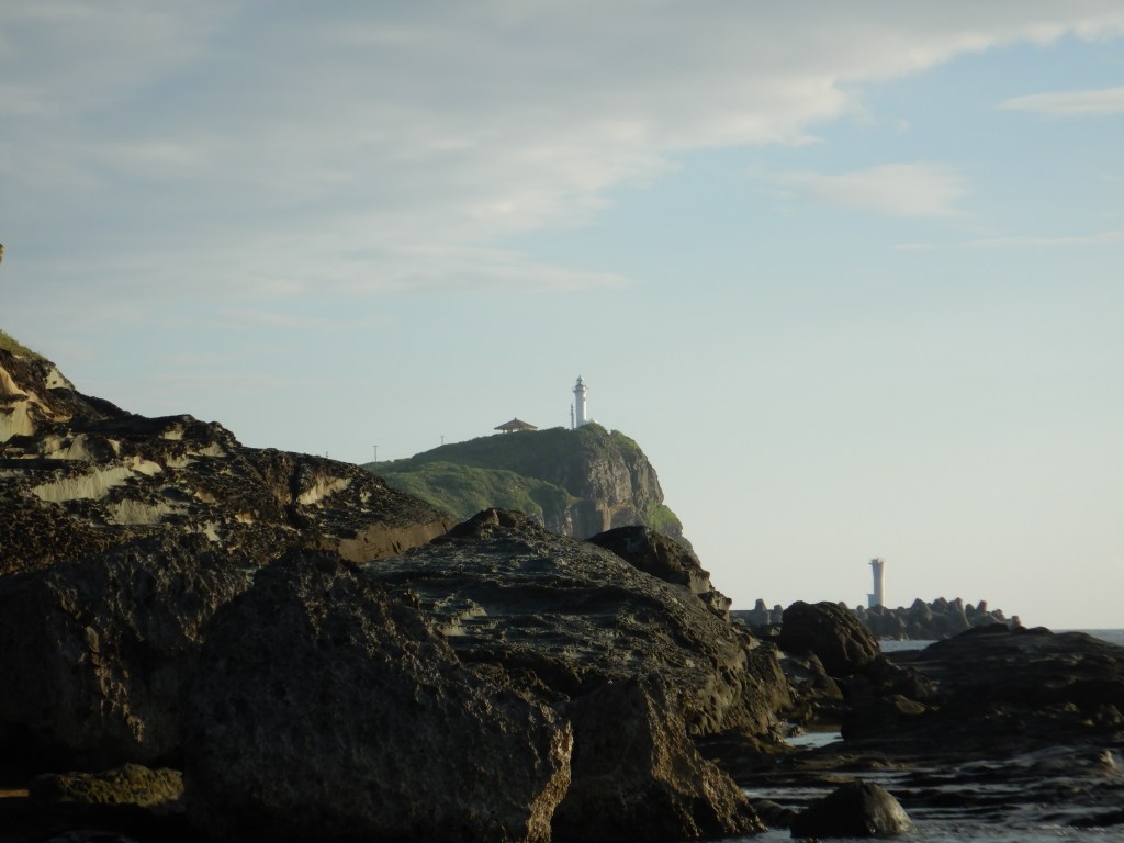
The island’s symbolic edge sits at the end of a short road southwest of Kubura port, with a monument marking the westernmost point of Japan, a lighthouse and a viewing platform on the clifftop. The sea beyond is the East China Sea, Taiwan is roughly 111 kilometres away, and on a clear day its silhouette is visible on the horizon. Because of the longitude, this is where the sun sets last in Japan, and the sunset is the main event; arrive forty minutes before to walk the headland and read the plaques. There is a car park, no admission charge and no facilities beyond a shelter and toilets, so bring water. Wind is constant and strong, and the path edges are unfenced in places, so keep children close and do not step past the barriers for a photograph.
The underwater formation, seen from a boat or on a dive
The reason Yonaguni appears in diving magazines is a stepped rock structure off the south coast, first reported by a local diver in 1986 and still argued over: some researchers read it as a man-made monument, others as a natural sandstone formation shaped by jointing and erosion. Either way, it is a spectacular dive, and it is not a beginner’s site, because current and swell at the point are strong and the dive depends on conditions. If you do not dive, several operators run glass-bottomed or semi-submersible boat trips that show the terraces without entering the water, which is the practical option for most visitors and for families. Book through your accommodation or a local shop, check the season, and treat any cancellation for sea conditions as normal rather than an inconvenience.
Cape Agari and the Yonaguni horses
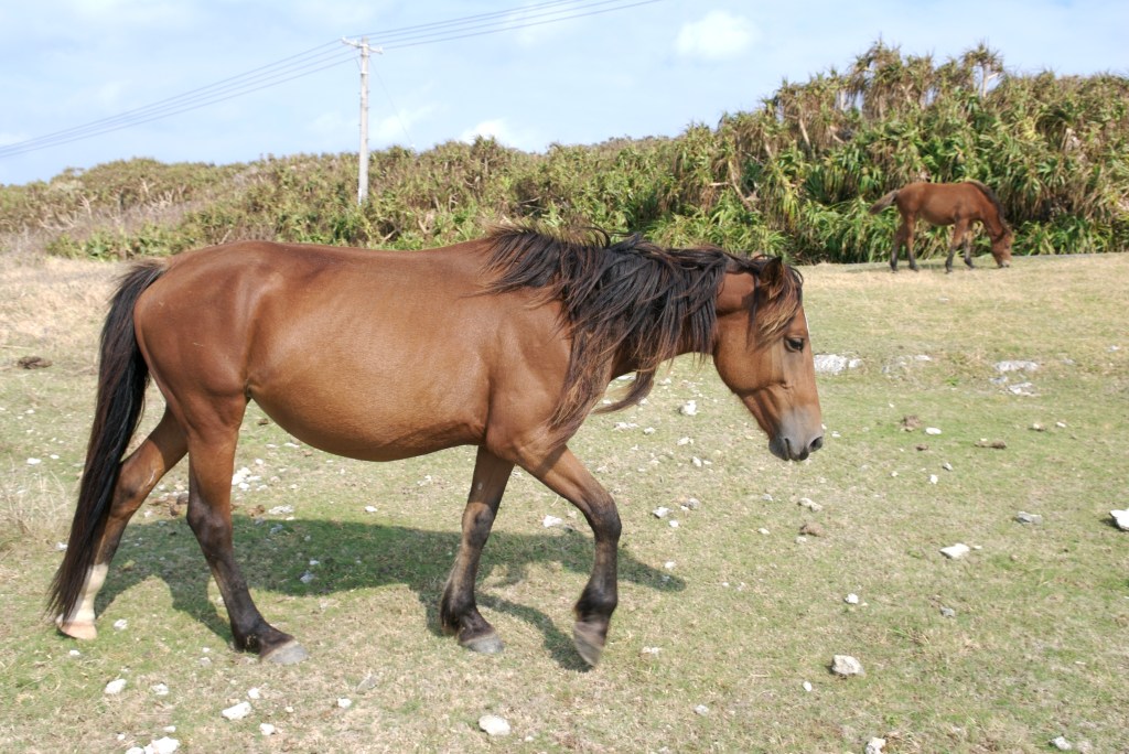
The eastern cape is a broad grassy headland above cliffs, and it is where you meet the Yonaguni horse, a small native breed that lives semi-wild across the island. They graze without fences here, which means you drive slowly, stop well short and never approach quickly or feed them. The view takes in the coast toward Iriomote on a clear day, and the wind turbines on the ridge behind have become part of the picture. Sunrise is the reason to come early; the light comes up over the sea and the horses are active. The road out is narrow and unlit, so if you are driving before dawn, take it slowly and watch for animals standing on the asphalt, which happens more than visitors expect.
Tindabana, the rock outcrop above Sonai
Tindabana is a natural rock formation with an eroded hollow that serves as a viewing platform over the village of Sonai, the fields and the sea. It is only a few minutes by car from the airport, which makes it the easiest introduction to the island’s geography and a good first stop after landing while you wait for luggage or a rental car. The site is associated with Sanai Isoba, the legendary female ruler said to have governed Yonaguni around the sixteenth century, and local people treat the spot with respect, so keep to the path and do not climb on the formation itself. There is parking and no charge. Late afternoon gives the best light for photographs toward the village, and the walk from the car park takes a few minutes on an uneven surface.
Ayamihabiru Museum and the world’s largest moth
The Yonaguni san is a moth with a wingspan of around twenty-four centimetres, designated a prefectural natural monument, and this small museum in the north of the island is built around it. Displays cover its life cycle, the relationship between the insect and the islanders, other insects and animals of the subtropics, and endangered species recorded here; during emergence periods you may see living specimens. It is a modest, old-fashioned museum rather than an attraction, and it is a good wet-weather option and a genuinely interesting one for children. Admission is 500 yen for adults and 300 yen for children, with reduced rates for groups of five or more. Opening hours are 10:00 to 16:00, and it closes on Tuesdays, public holidays and over the New Year, with free parking on site. It is about fifteen minutes by car from the airport.
The Dr. Koto clinic set at Hikawa
The television drama Dr. Koto’s Clinic was filmed here, and the clinic set at Hikawa on the north coast has been kept, with the waiting room and ward left close to how they appeared on screen. For Japanese visitors of a certain age this is a genuine pilgrimage; for everyone else it is an odd, charming piece of set dressing in a village with a good beach in front of it. The set is a short drive from the airport and can be visited without much planning, though opening arrangements have changed over the years, so confirm locally rather than assuming it is open. Even if the building is closed, Hikawa beach below is worth the stop: shallow, quiet and used mostly by residents. Combine it with the northern coast road, which is the island’s easiest drive.
Awamori and the island’s own drink
The island has its own awamori brand, Donan, distilled locally, and the distillery is one of the few indoor things to do that has nothing to do with the sea. Awamori is a Okinawan spirit made from rice and black koji, stronger than sake and usually drunk mixed with water or soda, and each island has its own character. Tours and tastings are not guaranteed and have depended on the season and staffing, so ask at your accommodation or telephone ahead rather than turning up. Bottles are easy to buy and make a good souvenir because they are heavy and awkward to find elsewhere. If you are driving, remember that the island’s roads are the only way around and the legal limit is effectively zero, so taste at the end of the day.
The three villages and the free community bus
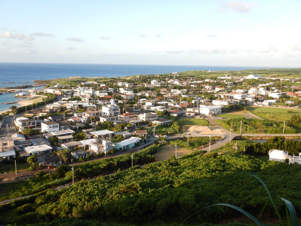
The island’s population of around 1,700 people lives in three villages, Sonai in the centre, Kubura in the west by the port, and Hikawa in the north, and each has a different feel: Sonai is the administrative centre with the town office and school, Kubura is the ferry port with the dive shops, and Hikawa is the quietest. Yonaguni town runs a free community bus linking the three, usable by anyone, with a revised timetable from 1 April 2026; it is the cheapest way to move if you cannot rent a vehicle. It does not go to Cape Agari, so the eastern cape needs a car, taxi or tour. Taxis exist but are few and should be booked, and rental cars, scooters and electric bicycles are limited enough that reserving before you arrive is strongly advised.
Food and drink
- The fisheries cooperative canteen in Kubura is the most reliable cheap meal on the island, serving what came in that day; its closing day changed from Sunday to Tuesday, so check before you go.
- Island cooking uses what keeps and what grows here: island vegetables, pork, dried fish and seaweed, with Okinawan staples such as goya and seaweed tempura appearing alongside local fish.
- Yonaguni soba and other noodle dishes are the standard lunch, and portions are sized for working people rather than tourists.
- Awamori from the island distillery is the drink to try; it is served with water or soda and is stronger than it tastes.
- Restaurant choice is very limited and several places close early or shut entirely in the off season. Ask your accommodation where is open on the night you arrive rather than driving around.
- There is no convenience store on the island and few ATMs, so bring enough cash for meals and fuel and buy food in Ishigaki or Naha before flying if you have special requirements.
Getting there and around
- By air from Ishigaki: about thirty minutes, three flights a day each way with Ryukyu Air Commuter, bookable through JAL. This is the practical route for most visitors.
- By air from Naha: the official island tourism site lists two flights a day each way, about one and a half hours, but the timetable changes seasonally, so confirm the current schedule when booking.
- By ferry from Ishigaki: the ferry Yonakuni runs twice a week, leaving Ishigaki on Mondays and Thursdays at 10:00 and arriving around 14:00, and returning on Tuesdays and Fridays at 09:00. The crossing takes roughly four hours and is frequently cancelled in rough weather.
- Flights are also affected by weather, including typhoons near Naha or Ishigaki rather than over Yonaguni itself, so avoid booking tight onward connections on the same day.
- On the island, rent a car, scooter or electric bicycle, all in limited numbers and best reserved in advance. There is a free community bus between the three villages, but it does not serve the eastern cape.
- The airport is small and the rental counters are opposite or inside it, so collect your vehicle on arrival rather than planning to walk anywhere from the terminal.
Where to stay
- Accommodation is small-scale: guesthouses, minshuku and a few hotels, several of them in Kubura near the port and dive shops, with others in Sonai and Hikawa.
- Book directly or through the tourism association rather than expecting a large booking inventory online, especially for the hammerhead season from January to March.
- Two nights is the sensible minimum. One night leaves no margin if a flight or ferry is cancelled, which happens often enough to plan for.
- Ask your accommodation about dinner. Many places provide meals for guests because the restaurant options on the island are so limited, and this is usually the best food you will eat there.
Best time to visit
- Winter into early spring, January to March, is hammerhead shark season for divers and the driest, clearest stretch for the cliffs and sunsets, though the wind is strong.
- Spring brings the island’s greenery and comfortable temperatures, and the moths emerge in the warmer months, which is when the museum’s living specimens are most likely.
- Summer is hot, humid and the peak of typhoon risk from July to October. Ferries are cancelled more often and flights are disrupted, so keep the schedule loose.
- Autumn stays warm into November and the sea remains diveable, but the same typhoon caveat applies through October. Winter days are mild by mainland standards and rarely cold enough to stop you walking.
Practical tips
- Build in a spare day. Flights and especially the ferry are cancelled for weather often enough that same-day connections are a real risk.
- Reserve a rental car before you arrive. Numbers are small and the island’s sights are spread along the coast with no practical alternative for the eastern cape.
- Carry cash. There is no convenience store, ATMs are limited, and several restaurants and shops do not take cards.
- Drive slowly and watch for horses, cows and people on the road, particularly at dawn and dusk and on the eastern cape road.
- Treat the underwater formation as an advanced dive site. Currents are strong; if you are not a confident diver, take the glass-bottomed boat instead.
- Do not approach or feed the Yonaguni horses, and do not enter sacred sites or private fields for a photograph.
- Check opening days before you set out: the moth museum closes Tuesdays and public holidays, and restaurant closing days shift with the season.
- Confirm the museum, distillery, ferry and flight details with the official Yonaguni tourism site or the operator directly, since timetables and closures change frequently on a small island.
Suggested day-trip outline
- Day 1, afternoon: land at Yonaguni airport, collect the rental car, stop at Tindabana on the way out, then drive to Cape Irizaki for the last sunset in Japan.
- Day 1, evening: check in at Kubura, eat at the fisheries canteen or at your accommodation, and confirm tomorrow’s sea conditions with a dive shop.
- Day 2, morning: dive or take the glass-bottomed boat to the underwater formation, then warm up with lunch in Kubura.
- Day 2, afternoon: drive east to Cape Agari for the horses and the clifftop view, returning via Hikawa beach and the Dr. Koto clinic set.
- Day 2, late afternoon: the moth museum if it is open and you still have energy, then the distillery or a bottle shop before dinner.
Before you go
Timetables, fares, admission fees, and seasonal access rules can change. Check the official tourism and transport sites linked below for the latest information before you travel.
Explore More of Japan
Published guides that pair with this one:
- Ishigaki Island Travel Guide: Yaeyama Beaches and the Ferry Hub
- Taketomi Island Travel Guide: Coral Sand, Village Lanes, and a Ferry from Ishigaki
- Iriomote Island Travel Guide: Mangroves, Jungle Rivers, and a Ferry from Ishigaki
- Hateruma Island Travel Guide: Japan’s Southernmost Inhabited Island
- Okinawa Travel Guide: Discover Japan’s Tropical Paradise
Browse every Okinawa guide on this site for the rest of the region.
Sources
- welcome-yonaguni.jp — Access (checked 2026-11-05)
- welcome-yonaguni.jp (checked 2026-11-05)
- welcome-yonaguni.jp (checked 2026-11-05)
- welcome-yonaguni.jp (checked 2026-11-05)
- welcome-yonaguni.jp (checked 2026-11-05)


Leave a Reply