Plan a visit to Mount Tsurugi in Tokushima, the highest peak in western Japan, with the ropeway, the summit trails and access.
Operational details such as opening hours, admission fees, and train times can change. Prefer official pages and reconfirm before you travel (sources checked on 03 November 2026).
Why visit
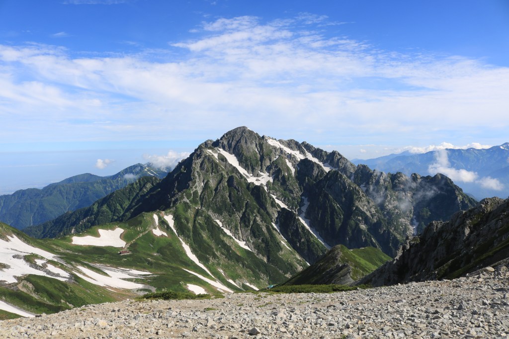
- Mount Tsurugi is 1,955 metres, the second-highest peak in western Japan after Mount Ishizuchi, and one of Japan’s hundred famous mountains. What makes it worth the journey is not the altitude but the shape of it: the summit ridge is covered in dwarf bamboo grass rather than forest, so the mountain opens out into long green slopes with scattered rock and a horizon that goes on for a hundred kilometres. There are very few places in Japan where a mountain of this height is this bare and this easy to stand on.
- The lift is why ordinary walkers can see it. A chairlift runs from Minokoshi at 1,420 metres to Nishijima at 1,750, climbing 330 metres of height over 830 metres of cable in about 15 minutes, at one metre per second. That puts the summit within an hour’s walk of anyone who can climb stairs, and it is the reason the mountain is a day out for families rather than an expedition. The lift carries 420 people an hour and has been running since 1970.
- The walking above the lift is genuinely good and gives you a choice. The ridge route reaches the summit in about 40 minutes over 900 metres and is the shortest and safest; the Okken Shrine route takes about 60 minutes over 1,200 metres past a shrine and a spring that is listed among Japan’s hundred best waters; and the promenade route takes about 80 minutes over 1,980 metres with a viewpoint where Tsurugi and Jirogyu can be seen side by side. None of them is technical, and all of them are above the treeline for much of the way.
- The plants are a specific reason to come in summer. The grassland ridge holds communities of alpine and subalpine flowers that survive because the site has been grazed and cut for centuries, including the yellow-flowered Kirengeshoma that was first described from this mountain, and the dwarf azalea that turns the ridge red in late spring. The mountain is a cultural landscape as much as a natural one, and the bare ridge is the result of human use rather than of altitude alone.
- The mountain has a religious layer that is easy to miss. The Okken Shrine sits below the summit, the spring beside it is used for ritual purification, and the opening of the climbing season on 29 April is marked at the Shrine with a procession carrying the portable shrine to the lift station and a mochi-throwing. The summit itself has a small shrine and a hut, and people stay overnight to see the sunrise over the Shikoku mountains.
- The practical case is the hard part and it should be stated plainly. Mount Tsurugi is deep in the interior of Shikoku, the access roads are narrow and slow, and the seasonal bus is expensive and does not run every day outside the summer peak. It is a full day from Tokushima or Kochi and a long day from Okayama, and it rewards people who accept that rather than people who try to fit it in.
Top places and highlights
The chairlift from Minokoshi
The lift climbs from Minokoshi at 1,420 metres to Nishijima at 1,750 in about 15 minutes, with the Shikoku mountains opening out on both sides and wild flowers at your feet for much of the ride. It runs from mid-April to the end of November, normally 9:00 to 16:30 but from 8:00 during Golden Week, in August and on October weekends, and it takes cash only. The adult return is 2,300 yen and a single is 1,300.
The summit ridge and its grassland
Above Nishijima the mountain opens into slopes of dwarf bamboo with rock outcrops and almost no trees, and the ridge runs south towards the summit at 1,955 metres. The bareness is the result of centuries of grazing and cutting rather than of altitude, and it is what gives the mountain its distinctive look. On a clear day the view takes in the ridges of Shikoku in every direction and, in winter, snow on the higher peaks.
The Okken Shrine route
The route through Okken Shrine takes about 60 minutes over 1,200 metres, and it is the one to take if you want the religious side of the mountain rather than only the view. The shrine sits below the summit and the spring nearby, Tsurugi Gojin-sui, is listed among Japan’s hundred best waters, so the walk includes a place to fill a bottle. It is slightly longer than the ridge route and much less crowded.
The promenade route and the Nidomi viewpoint
The longest of the three routes takes about 80 minutes over 1,980 metres and is designed for people who want to take their time. Its reward is the Nidomi viewpoint, where Tsurugi and the neighbouring Jirogyu ridge can be seen together, which is the view that explains the shape of the massif. It is the route for a summer day when the flowers are out and there is no reason to hurry.
Kirengeshoma and the summer flowers
The mountain is the type locality for Kirengeshoma palmata, the yellow-flowered plant that blooms in late summer in the shaded edges of the grassland, and the ridge holds a wide range of subalpine flowers through July and August. The dwarf azalea turns the slopes red in late May and early June. This is the specific reason botanists come to Tsurugi rather than to a higher or more famous peak.
The sunrise from the summit hut
There are two mountain huts near the top, Tsurugi-san Chojo Hutte and Unkaiso, and staying in one is the way to see the sunrise over the Shikoku mountains from the summit. It also solves the access problem, since the drive and the lift take most of a morning from the nearest city. The huts serve meals and sell supplies, and they need booking in the season.
The autumn colour and the momiji festival
The grassland turns gold and rust in October, and the lift operator holds a momiji festival that month, with the service starting an hour earlier at 8:00 on weekends and holidays to cope with the crowds. The colour on a bare ridge is different from colour in a forest: the whole slope changes at once rather than in layers, and the contrast with the rock is what makes it worth the trip.
Food and drink
- There is nothing to eat at the lift station, and the mountain huts at the summit serve simple meals to guests and sometimes to day visitors. The practical advice is to bring food and water from the valley, because the nearest shops are an hour’s drive away.
- The base area around Minokoshi has a small rest house with light meals in season, and the roadside station at Sadamitsu on the bus route sells local produce and boxed lunches. That is the last proper stop before the climb, and it is where to buy lunch.
- The local food of the region is Iya soba, made from buckwheat grown on the steep slopes of the Iya valley, and it is served in the villages along the Ikeda route. The other speciality is the wild plant cooking and the river fish of the Yoshino river, which is best eaten in the valley rather than on the mountain.
- The sake and the sudachi citrus of Tokushima are the take-home items, and the roadside stations on the way up stock both. The sudachi is used in cooking across the prefecture and is the one ingredient that identifies the food of this part of Shikoku.
Getting there and around
- By public transport, the seasonal Gurutto Tsurugi Tozan bus runs from JR Sadamitsu Station and the Sadamitsu roadside station to Minokoshi, taking about two hours and costing 3,000 yen one way. It runs on weekends and holidays from 18 April to 31 May and from 4 July to 15 November, and daily from 8 to 16 August, with two departures a day in each direction.
- The other seasonal bus runs from Awa-Ikeda bus terminal and stops at Oboke Station, taking about three hours and costing 3,170 yen from Ikeda or 2,620 from Oboke. It runs on weekends and holidays from 18 April to 23 November, and daily in Golden Week, from 4 July to 31 August and from 1 October to 3 November.
- By car, the routes are the Sadamitsu and Utsuno route from the Mima interchange on the Tokushima Expressway, about 90 minutes via Route 438; the Anauchi and Koyadaira route from the Wajimachi interchange, about 100 minutes; or the Ikeda and Higashi-Iya route from the Ikeda interchange, about 120 minutes via Routes 32 and 439. The 438 is narrow, often single-lane, and difficult to pass oncoming traffic in places.
- Winter closures matter: the Sadamitsu route closes completely at night from late December to 31 March, with daytime access from 8:00 to 18:00, while the Anauchi route closes completely and the Ikeda route closes from early January to 31 March. Driving up in winter requires a four-wheel-drive vehicle and winter tyres, and the lift does not run in winter anyway.
- There are three car parks at Minokoshi: the first is a minute from the lift station, a new one is 170 metres away, and the second is 15 minutes away at 1.5 kilometres. They fill from the nearest in peak season, and road parking is prohibited because the road is too narrow for buses and residents to pass.
Where to stay
- The Tsurugi-san Chojo Hutte and Unkaiso near the summit are the way to be on the mountain at sunrise, with meals and simple rooms, and they need booking in the season. They are mountain huts rather than hotels, and the facilities are shared.
- The Iya valley, along the Ikeda route, has ryokan, onsen and the famous vine bridges, and staying there turns the mountain into a two-day trip through one of Japan’s most dramatic valleys. It is the best base for anyone who wants more than the summit.
- Sadamitsu and Mima, on the Tokushima Expressway side, have business hotels and are the practical base if you are driving and want an early start. Ikeda has more options and is also the transport hub for the valley.
Best time to visit
- The lift runs from mid-April to the end of November, and that window defines the season. Opening is marked on 29 April at the Okken Shrine with a procession and a mochi-throwing, and the mountain is busy through Golden Week.
- Late May and June bring the dwarf azalea on the ridge, which is the most colourful the mountain gets, and the fresh green of the bamboo grass. The weather is changeable and the summit can be in cloud while the valley is clear.
- July and August are the flower season, with Kirengeshoma and the subalpine plants out, and the lift starts at 8:00 through August. It is also the wettest period and the most humid, and afternoon thunderstorms are a real risk above the treeline.
- October is the autumn peak, with the grassland turning and the operator running the momiji festival and early starts at 8:00 on weekends. November is quieter and colder, and the lift closes at the end of the month, after which the mountain is for equipped winter climbers only.
Practical tips
- Bring cash. The lift takes cash only, with no cards and no IC payment, and the round trip is 2,300 yen for adults and 1,100 for children. There is no ATM at Minokoshi and the nearest ones are in the valley.
- Check the bus calendar before you plan. The seasonal buses run on weekends and holidays outside the summer peak, with only two departures a day, and the Sadamitsu route stops in mid-November while the lift runs to the end of the month. A weekday visit outside August needs a car.
- Allow for the road, not just the distance. Route 438 from Sadamitsu is about 90 minutes for a short distance on the map because it is narrow and winding, and parts of it are a single lane. Driving up in the dark or in rain is not advisable.
- Take the Okken Shrine route up if you have the time. It is 20 minutes longer than the ridge route but it passes the shrine and the spring listed among Japan’s hundred best waters, and it is far less busy. Come down the ridge route for the shortest descent.
- Start early even with the lift. The first lift is at 9:00 normally, the walk to the summit takes 40 to 80 minutes depending on the route, and the last lift down is at 16:30. In October the weekend service starts at 8:00, which is the best window for the sunrise and for avoiding the queue.
- Carry water and a windproof layer. The ridge is bare and exposed, the temperature at 1,950 metres is well below the valley, and there is nowhere to buy anything between Minokoshi and the summit huts. Even in August the wind on the ridge can be cold.
- Check the road closure information on the day. The routes close in winter and can close for construction or landslides at any time, and the prefecture publishes a live road restriction map. The mountain is deep in the interior and there is no alternative route that is quick.
Suggested day-trip outline
- Leave the Tokushima Expressway at the Mima interchange and drive Route 438 for about 90 minutes to Minokoshi, or take the seasonal bus from JR Sadamitsu Station at 7:50. Park in the first car park if it is early, and buy a return lift ticket with cash.
- Ride the chairlift to Nishijima, 15 minutes, and take the Okken Shrine route up, about 60 minutes, stopping at the shrine and filling a bottle at the spring. If you are short of time, take the ridge route instead, which reaches the summit in about 40 minutes.
- Spend time on the summit ridge rather than turning straight round. The grassland and the view are the reason for the climb, and the ridge running south gives a longer walk with fewer people. Eat what you carried, since there is no food service on the summit for day visitors.
- Come down by the promenade route, about 80 minutes, for the Nidomi viewpoint and the flowers, and take the last lift down well before 16:30. In October, arrive for the 8:00 service and you will have the ridge to yourself for the first hour.
- Drive on to the Iya valley or Oboke for the night, or back to Ikeda for the train. If you are staying in a summit hut, the itinerary shifts by a day and the reward is the sunrise over the Shikoku mountains from the highest point in western Japan after Ishizuchi.
Before you go
Timetables, fares, admission fees, and seasonal access rules can change. Check the official tourism and transport sites linked below for the latest information before you travel.
Explore More of Japan
Published guides that pair with this one:
- Iya Valley Travel Guide: Vine Bridges and Mountain Villages
- Oboke Gorge Travel Guide: The Yoshino River between the Cliffs
- Mount Ishizuchi Guide: Shikoku’s Highest Peak
- Shimanto River Travel Guide: Japan’s Last Clear Stream and the Boats That Drift It
- Kotohira Travel Guide: Konpira Shrine Stairs and Shikoku Pilgrim Town
- Awa Odori Guide: Tokushima’s August Dance Festival
- Naruto Travel Guide: Whirlpools under the Onaruto Bridge
- Shikokumura Open-Air Architecture Museum Travel Guide: Highlights, Access, and Planning
- The Museum of Art, Ehime Travel Guide: Highlights, Access, and Planning
- Cape Ashizuri Guide: Kochi’s Southern Tip
Browse every Shikoku guide on this site for the rest of the region.
Sources
- turugirift.com — Visitor guide (checked 2026-11-03)
- turugirift.com (checked 2026-11-03)
- nishi-awa.jp (checked 2026-11-03)
- awanavi.jp (checked 2026-11-03)
- awanavi.jp (checked 2026-11-03)


Leave a Reply