A practical English guide to Tsushima: ferries and flights from Fukuoka, Aso Bay viewpoints, Watatsumi Shrine, Izuhara town and driving the island.
Operational details such as opening hours, admission fees, and train times can change. Prefer official pages and reconfirm before you travel (sources checked on 05 November 2026).
Why visit
- Tsushima is a long, thin island in the strait between Kyushu and Korea, 82 kilometres from north to south and only 18 across, and it is closer to Busan than to Tokyo. That position has shaped everything about it: it was the island the Japanese state used to receive and manage contact with the continent, the place where the Mongol invasions landed in 1274 and 1281, and the home of the So family, who governed it for centuries as a semi-independent domain.
- For a traveller, the result is a place unlike anywhere else in Japan. There are Buddhist temples and Shinto shrines in the usual Japanese forms, a castle site and a Confucian school, and mixed into them a landscape of rias coastline so indented that Aso Bay alone contains dozens of inlets and islands. The food is a mix of Kyushu and Korean influences, the forests hold a subspecies of wildcat found nowhere else on earth, and the borders are visible in everything from road signs to the number of Korean visitors.
- The island is not convenient to visit: the fast ferry from Fukuoka takes a little over two hours, the flight 35 minutes, and once there you need a car to see anything beyond Izuhara. But that difficulty is also what keeps it quiet. Tsushima has the scenery of a top-tier Japanese island destination and a fraction of the visitors.
- It rewards a two-day trip rather than a rushed one. The south, where the ferry lands, is the historical core: Izuhara’s old streets, the So family temples, the castle ruins under the cherry trees. The centre is the scenery: Aso Bay’s rias coastline, Mount Eboshi’s 360-degree viewpoint, and Watatsumi Shrine standing in the water. The north is wilder, with the cat sanctuary near the peninsula’s tip and a lookout from which Korea is visible on a clear day.
Top places and highlights
Aso Bay and the rias coast
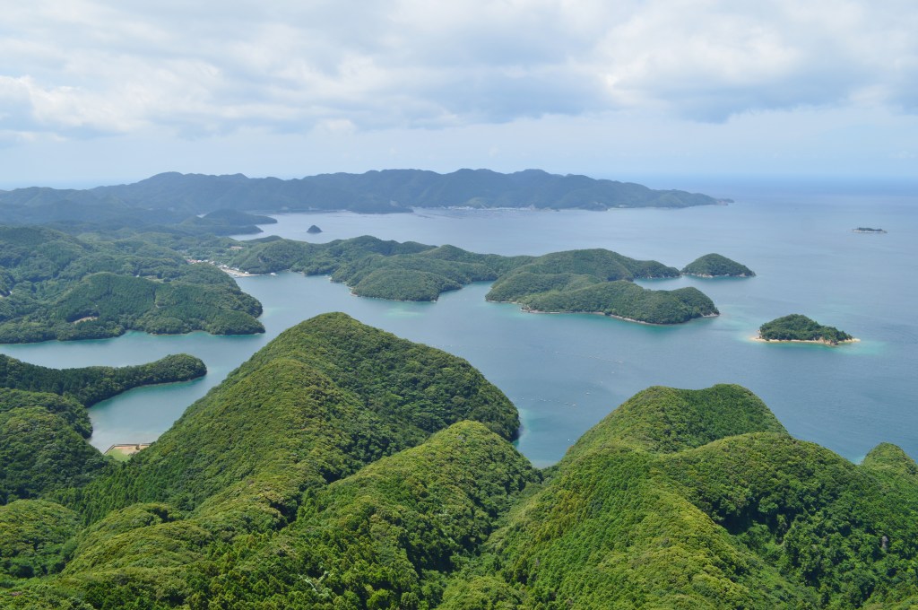
Aso Bay is the centrepiece of the island, a deep inlet on the north side of the southern block with a coastline that fragments into channels, peninsulas and dozens of wooded islets. Views from the connecting bridge at Mankanzakura and from the viewpoints above make the geography clear: this is a drowned mountain range, not a single bay, and the water is a deep blue. A cruise boat runs through the bay, which is the best way to see the scale, though the viewpoints cost nothing and give the panorama. The bridge at Manzeki is itself worth stopping for: a channel dug by the Imperial Navy in the Meiji period to let ships pass between the two halves of the island, cutting a section that had been dry land. There is a small lookout on the north side that takes in the bay on one side and Miura Bay on the other.
Mount Eboshi
The lookout on Mount Eboshi, at 176 metres, is the most celebrated view on the island and the one photograph everyone brings back. From the car park a staircase of about 145 steps leads to a small platform, and from there it is 360 degrees of Aso Bay: the channels, the islands, the ridges, and on a clear day the mountains of Korea in the distance. It is best at sunset, and the local advice is to be at the car park about fifteen minutes before the sun goes down, since the stairs take time and the light goes quickly. The south-western corner of the platform gives the classic shot. There is no facility beyond the car park, so go prepared, and do not attempt the stairs in poor light without a torch.
Watatsumi Shrine
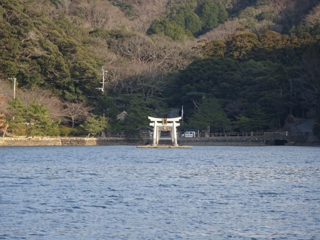
Watatsumi Shrine stands on the shore of Aso Bay and is unusual because its torii stand in the sea. The shrine is dedicated to Hoori and Toyotama-hime, the deities of the Hoho-demi and sea-god myth in which a fisherman marries the daughter of the sea king, and it is associated with the dragon palace of that story. Five torii lead towards the shrine, and at high tide two of them are in the water, so the appearance changes completely with the tide. At low tide you can walk out to the first torii; at high tide the water comes up to the shrine buildings and sea kayaking around the torii is possible with a booking. It is free, open at all times, and about 55 minutes by car from Izuhara, which makes it a natural stop on the way up the island.
Izuhara and the So family sites
Izuhara, the small town where the ferries land, was the castle town of the So family and still holds the island’s densest concentration of history within walking distance. The Kaneda castle ruins sit above the town, and the old Kaneda castle garden below them is a formal garden whose pond is laid out in the shape of the character for heart. Mansho-ji, the family temple of the So, holds memorial tablets of the Tokugawa shoguns and gifts sent by Korean kings, and the approach climbs 132 stone steps, the Hyakugangi, past a cedar more than a thousand years old. The tourist information office, Fureai-dokoro Tsushima, is the place to book a guided walk, which takes about two hours and is the easiest way to understand what you are looking at. The town has a small, walkable centre and a good view back over the harbour.
The northern tip and the wildcat
The northern half of the island is wilder and emptier, with a road running up to the tip and a lookout from which Korea is visible across the strait on a clear day. The Tsushima Wildlife Conservation Centre near Sago houses the official programme for the Tsushima leopard cat, a subspecies found only on this island and now critically endangered, with a small exhibition and rescued animals. It is free, open from 10:00 to 16:00 with last entry at 16:30, closed on Mondays and the following day if Monday is a holiday, and closed over the New Year period. The north is also where the island’s best beaches are, and where the 1274 Mongol landing is commemorated, at Komoda beach on the west coast, where a small shrine and monument mark the site.
Driving the island
Tsushima is not a place to see on foot beyond Izuhara, and the drive itself is the attraction. Route 382 runs the length of the island, and the four hours it takes to drive from Izuhara to the northern tip and back passes through every landscape the island has: the rias of Aso Bay, terraced rice fields, cedar forest, fishing villages in sheltered inlets, and long stretches of empty coast. Rental cars are available at Izuhara port and at the airport, and should be booked in advance, especially in summer and around holidays, because the fleets are small. Note that the road is single-carriageway in places, that the northern half has few petrol stations and restaurants, and that driving times on a map of this island are optimistic: the distance is short but the road is slow. Fill the tank in Izuhara or Hitakatsu and carry water.
Food and drink
- Tsushima’s seafood is the reason to eat here: anago conger eel, amadai tilefish and akamutsu blackthroat seaperch appear in season, and the simplest way to have them is as sashimi or grilled.
- Ishiyaki is the local speciality worth seeking out: seafood grilled on a hot slab of quartz porphyry, a rock found on the island. The stone holds the heat and the fish cooks at the table, which is both theatre and a good way to eat.
- Tonchan, pork seasoned sweet and spicy, is a Tsushima dish with Korean roots and appears in rice bowls and as a side dish. It reflects the island’s long contact with the peninsula more plainly than any museum exhibit.
- Kasumaki is the local sweet: a generous amount of smooth bean paste wrapped in a thin wheat casing. It is sold at the tourist office and shops in Izuhara and makes an easy gift.
- Tsushima soba, buckwheat noodles, is a local speciality served in a number of shops, with a taste that differs from the mainland versions. It is a good lunch between sights.
- Restaurants are concentrated in Izuhara and Hitakatsu, and the north of the island has very few. Plan meals around the towns rather than assuming you can stop anywhere on the road.
Getting there and around
- By air, ANA flies from Fukuoka to Tsushima Yamane-ko Airport in about 35 minutes, five round trips a day; from Nagasaki the flight is also about 35 minutes on ANA or Oriental Air Bridge, four to five round trips a day. A bus from the airport to Izuhara takes about 27 minutes.
- By sea from Fukuoka, the Kyushu Yusen jetfoil runs from Hakata to Izuhara in about 2 hours 15 minutes, twice a day, and the passenger ferry takes about 4 hours 40 minutes, also twice a day. The jetfoil is all-reserved seating.
- A slower ferry also runs from Hakata to Hitakatsu in the north of the island, about 5 hours, once a day, which saves the drive if you are heading straight to the northern end.
- There are international high-speed services between Izuhara or Hitakatsu and Busan in Korea, which is one reason the island’s tourist infrastructure has Korean signage and a steady flow of visitors from the peninsula.
- Once on the island, a rental car is effectively essential. Buses exist, with a one-day pass around 1,040 yen sold at the tourist office, but they are infrequent and do not reach the viewpoints and shrine conveniently.
- Distances are deceptive: the island is 82 kilometres long, and driving from Izuhara to the northern tip takes well over an hour on roads that are narrow in places. Plan the day around one or two areas rather than trying to see everything.
Where to stay
- Izuhara, around the ferry port and the old town, is the most convenient base, with business hotels, small inns and guesthouses within walking distance of the historic sites and restaurants.
- Hitakatsu, in the north, is the base for the northern half: fewer beds, but closer to the wildcat centre, the beaches and the lookout towards Korea. It also has the ferry link to Hakata.
- Aso Bay and the centre of the island have a handful of ryokan and minshuku, some with sea views. They are quiet and inconvenient without a car, which is fine if you have one.
- Book accommodation early in summer and around Japanese holidays; the island’s room stock is small relative to demand in those periods, and the ferries fill.
Best time to visit
- Spring is the best all-round season: mild, green, and the cherry trees around Kaneda castle and the Izuhara temples come into flower. The sea is calm enough for the jetfoil and the viewpoints are clear.
- Summer is warm and good for the northern beaches and sea kayaking, but the island is humid, the ferries can be cancelled in typhoons, and rental cars and rooms book out.
- Autumn brings clear air, which matters here more than foliage: the views from Mount Eboshi towards Korea are best in the cooler months, and the seafood is at its strongest.
- Winter is cold, windy and quiet, with rough seas that can suspend the jetfoil. It is the season for the island’s own pace, but build flexibility into the travel days and confirm sailings rather than assuming them.
Practical tips
- Book the rental car before you book anything else. The fleets are small, the island cannot be seen without one, and there is no alternative that reaches the viewpoints.
- Carry cash. The north of the island has few ATMs, and many small restaurants and shops do not take cards.
- Check the tide before visiting Watatsumi Shrine. At high tide the torii stand in the water and the shrine is at its most photogenic; at low tide you can walk out, but the effect is different.
- Time Mount Eboshi for sunset, arriving at the car park about fifteen minutes early to allow for the 145 steps, and bring a torch for the descent.
- Do not underestimate driving times. The island is long, the roads are narrow, and a plan that looks reasonable on a map will not fit into a day.
- The jetfoil is all reserved and can be cancelled in rough weather. If the sea is up, the flight is the fallback, so check both rather than committing to one.
- The Tsushima leopard cat is real, endangered and almost never seen. Do not expect to spot one on the road; the conservation centre is where to learn about it.
- Respect the border setting. There are self-defence force facilities and restricted areas on the island, and photographing them is not appropriate. Signs are clear; follow them.
Suggested day-trip outline
- Day 1, morning: jetfoil from Hakata to Izuhara, collect the rental car, and walk the old town with a guided tour from the tourist office, taking in Mansho-ji and the Kaneda castle garden.
- Day 1, afternoon: drive north to Aso Bay, stop at the Manzeki bridge and lookout, then Watatsumi Shrine depending on the tide.
- Day 1, evening: Mount Eboshi for sunset, then back to Izuhara or on to a minshuku near the bay for the night.
- Day 2, morning: drive north along Route 382 through the fishing villages to the conservation centre and the northern tip, with a stop at Komoda beach on the west coast.
- Day 2, afternoon: return south for the ferry or flight, allowing more time than the map suggests for the drive back.
Before you go
Timetables, fares, admission fees, and seasonal access rules can change. Check the official tourism and transport sites linked below for the latest information before you travel.
Explore More of Japan
Published guides that pair with this one:
- Nagasaki Travel Guide: Harbor History, Hills, and Kyushu Flavors
- Hirado Travel Guide: Nagasaki’s Island of Churches and Castles
- Kujukushima and Sasebo Guide: Islands, Cruises and the Naval Port
- Mojiko Retro and Kanmon Strait Travel Guide
- Tanegashima Travel Guide: Rockets, Firearms History and Quiet Beaches
- Usuki Stone Buddhas Travel Guide: Japan’s National Treasure Cliff Carvings
- Nagasaki Atomic Bomb Museum Travel Guide: Highlights, Access, and Planning
- Nagasaki Bio Park Travel Guide: Highlights, Access, and Planning
- Yanagawa Travel Guide: Canals, Boat Rides and Eel
Browse every Kyushu guide on this site for the rest of the region.
Sources
- tsushimabiyori.jp — Access (checked 2026-11-05)
- city.tsushima.nagasaki.jp (checked 2026-11-05)
- tsushima-net.org (checked 2026-11-05)
- nagasaki-tabinet.com (checked 2026-11-05)
- mapple.net (checked 2026-11-05)


Leave a Reply